Unsere Features
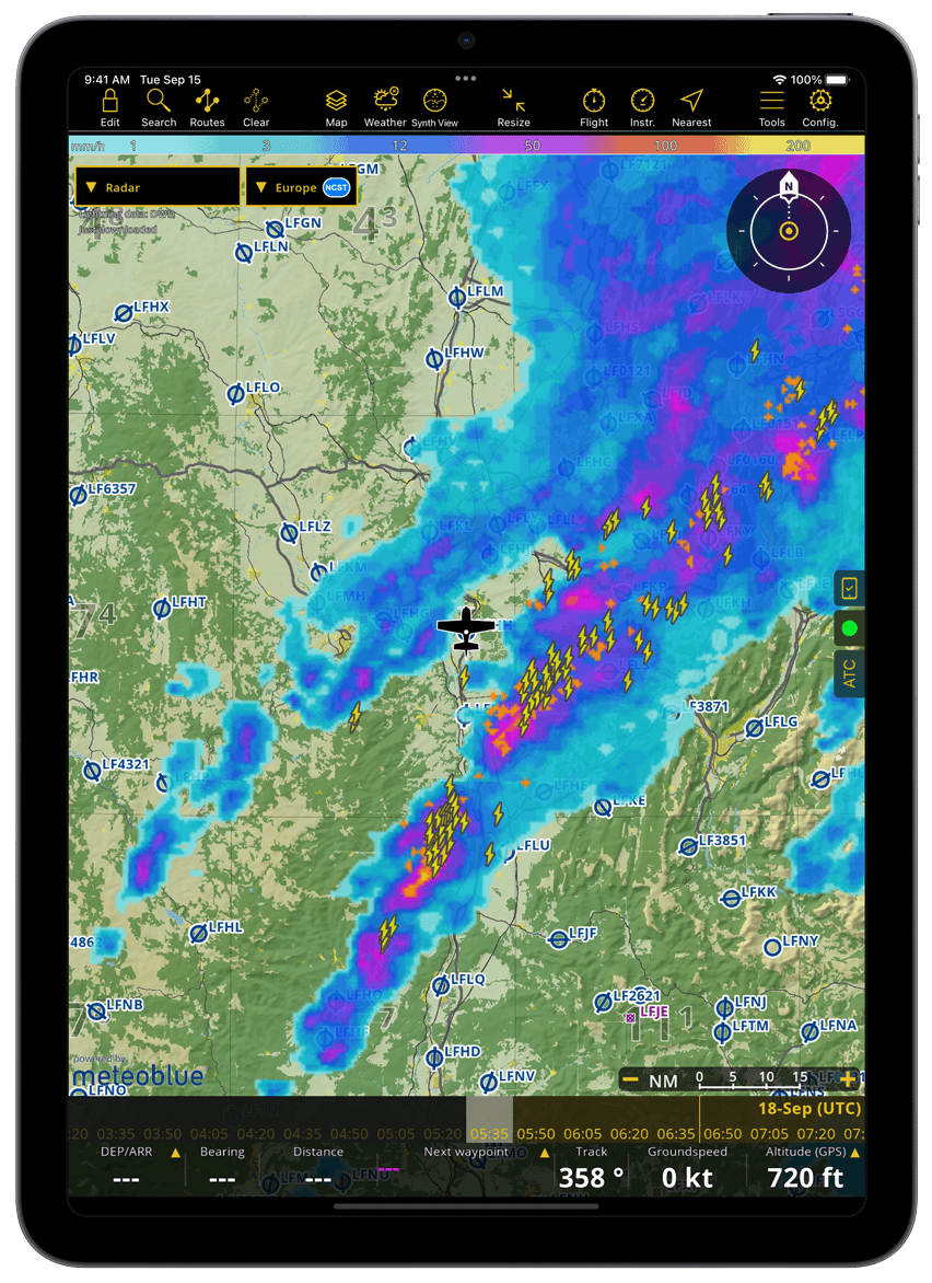
Wetter (in alle Premium Pakete inbegriffen)
- Überprüfen Sie die Wettervorhersage für bis zu 3 Tage im Voraus.
- Anzeige auf der Karte: Regenradar, Wind, Wolken und Regen, Gafor (CH und DE), Böen, Sichtweite und Druckmodule
- Die Wetterdaten werden über Ihre Internetverbindung ständig aktualisiert. Wettervorhersagen sind auch offline verfügbar.
- Wetterberichte sind im Briefing enthalten.
Flugplanungsfunktion
- Erstellen Sie in wenigen Sekunden eine Route auf der interaktiven Karte oder durch Eingabe einer oder mehrerer ICAO-Kennungen
- Überprüfen Sie wichtige aeronautische und meteorologische Informationen zu Ihrem Flug (NOTAM, METAR, TAF, Wind)
- Flugdokumente erstellen, drucken oder teilen (Navigationsplan, Gewicht und Balance, NOTAM-Briefing)
- Reichen Sie einen ATC-Flugplan ein
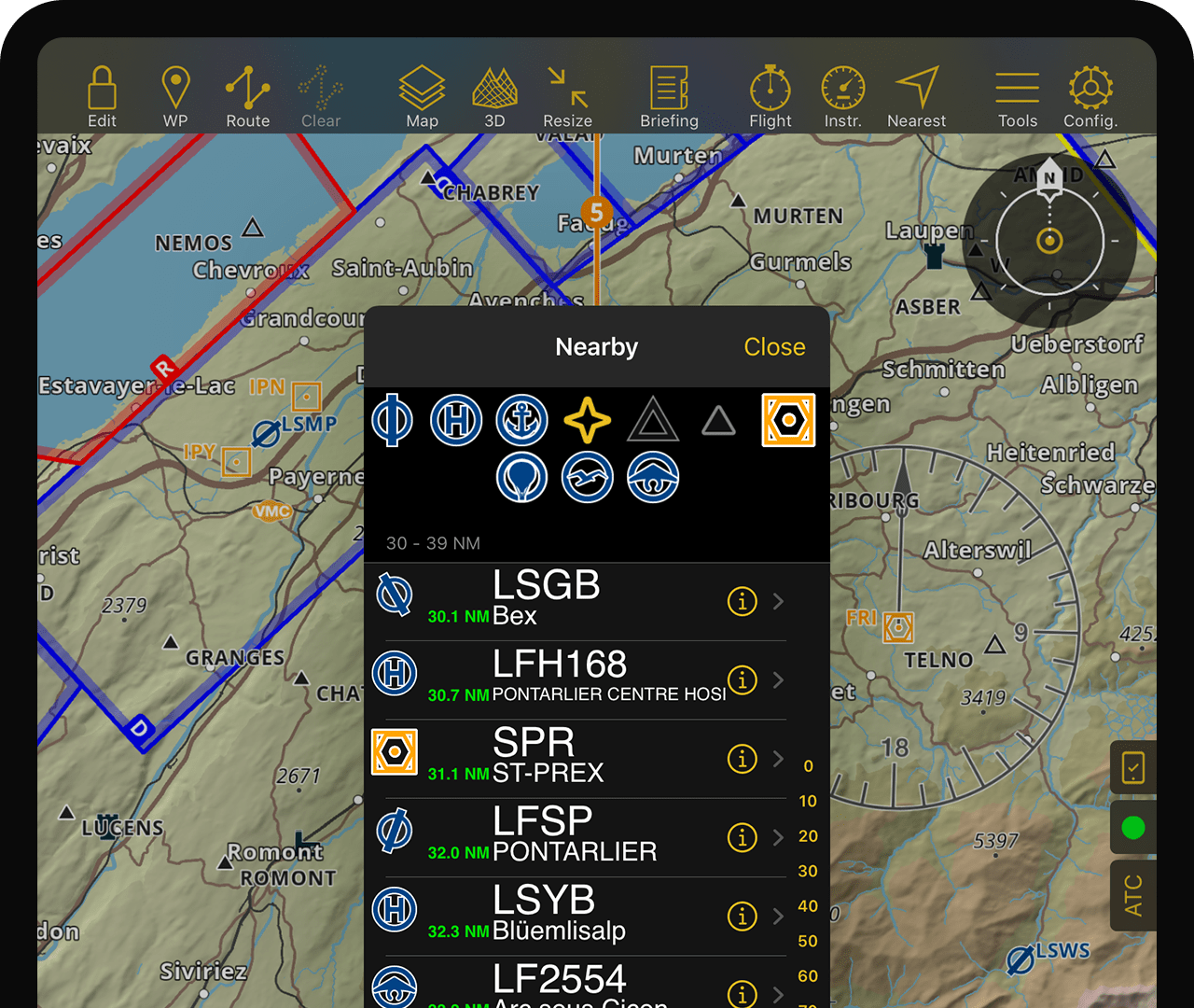
Interaktive Vektorkarte
- Smartchart: Weltweites Terrain, Wegpunkte, Lufträume, NOTAM, Toponyme, Straßen, Städte, Landmarken
- Geben Sie Wegpunkte, Lufträume oder detaillierte NOTAM-Informationen durch einfaches Antippen preis
- Hindernisse für ausgewählte Länder

Aeronautische Karten
- Offizielle ICAO-Rasterkarte für die meisten europäischen Länder
- Schnitt- und Weltrasterkarten für die USA
- Luftfahrtkarten von Drittanbietern für Kanada, Südamerika, Russland, Australien und verschiedene andere Länder
- Topografische Karten für verschiedene europäische Länder
- Weltweite kostenlose ONC- oder OSM-Karten für Länder, die keine anderen Karten haben
Datenbank
- Umfassende weltweite Datenbank mit Wegpunkten und Lufträumen
- Die Datenbank wird alle 28 Tage nach dem AIRAC-Zyklus aktualisiert
- Die Hindernisdatenbank wird wöchentlich aktualisiert
- Weltweite Straßen- und Adressdatenbank
Interaktive NOTAM
- NOTAMs werden alle 5 Minuten aktualisiert
- Die detaillierten Informationen von NOTAMs können durch einfaches Antippen der Karte oder durch Generieren eines Routenbriefings angezeigt werden
ATC Flugplan
- Der ATC-Flugplan ist mit Ihren ausgewählten Flugzeuginformationen vorausgefüllt
- Kann einfach innerhalb der Bewerbung eingereicht werden
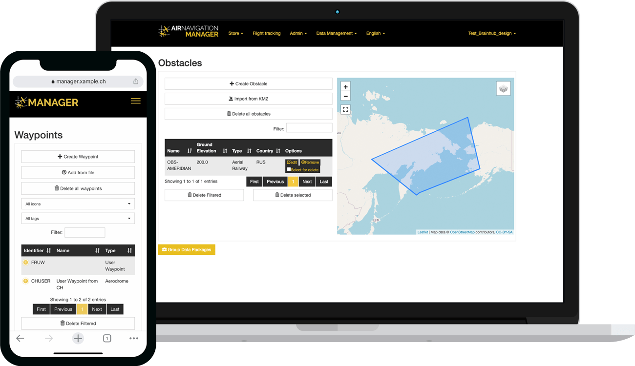
Funktionen Manager
- Für Betreiber: Verwalten Sie eine Tablet-Flotte, indem Sie Unternehmensdaten mit Ihren Piloten teilen und synchronisieren (spezielles Geschäftsabonnement erforderlich)
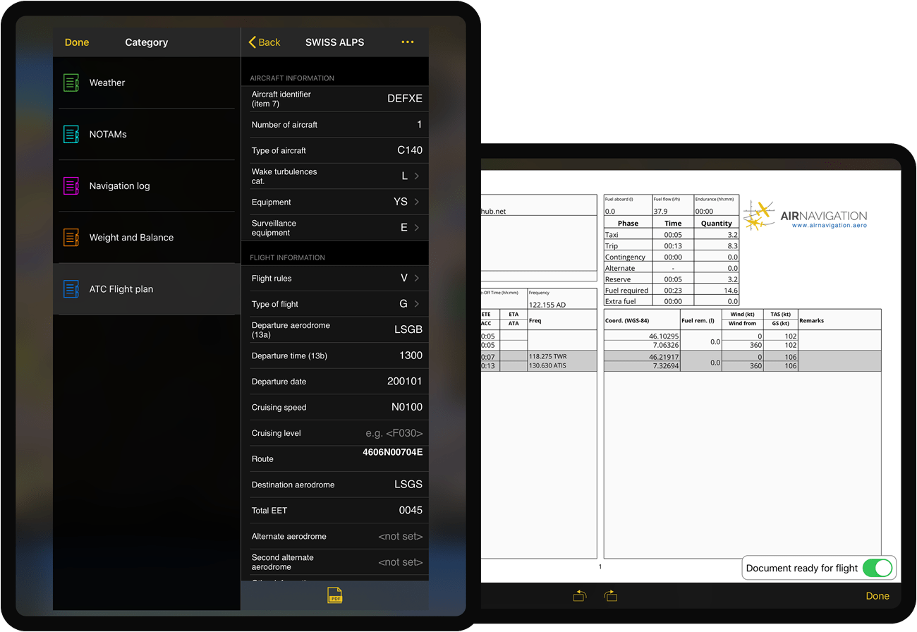
Briefing
Das interaktive Briefing-Menü ermöglicht Ihnen die Erstellung und Erstellung von Flugdokumenten. Das System erstellt schnell Wetter- und NOTAM-Briefings, Navigationsprotokolle, W&B-Sheets oder ATC-Flugpläne. Dokumente können als PDF gespeichert und exportiert werden.
Wenn Sie Standard- oder Premium-Abonnent sind, können Sie Ihre ATC-Flugpläne direkt aus der App an den Flugverkehrsdienst übermitteln.
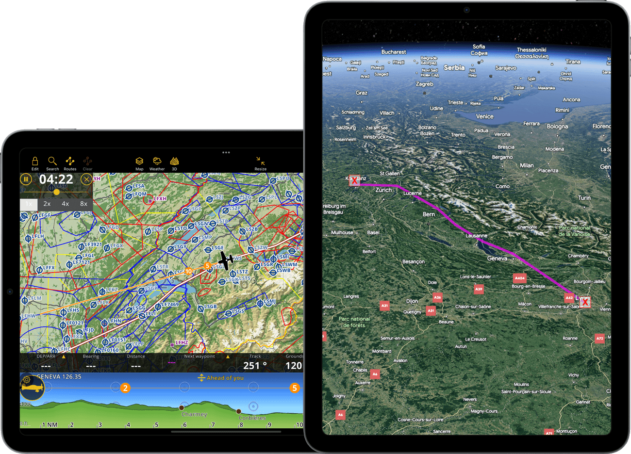
Moving Map
- Nord- oder kursorientiert, folgt Ihrer aktuellen GPS-Position
- Verfolgen Sie Ihre geplante Route auf der Moving Map oder mithilfe von Streckenwerten
- Vermeiden Sie Geländegefahren mit dem integrierten TAWS und Ihrer aktuellen GPS- oder Barometer-gemeldeten Höhe
- Navigationswerte in Echtzeit (Geschwindigkeit, Kurs, Peilung und ETE zum nächsten WP und vieles mehr)
- NOTAM und Hinweismeldungen anderer Piloten
- Sonstiger Verkehr
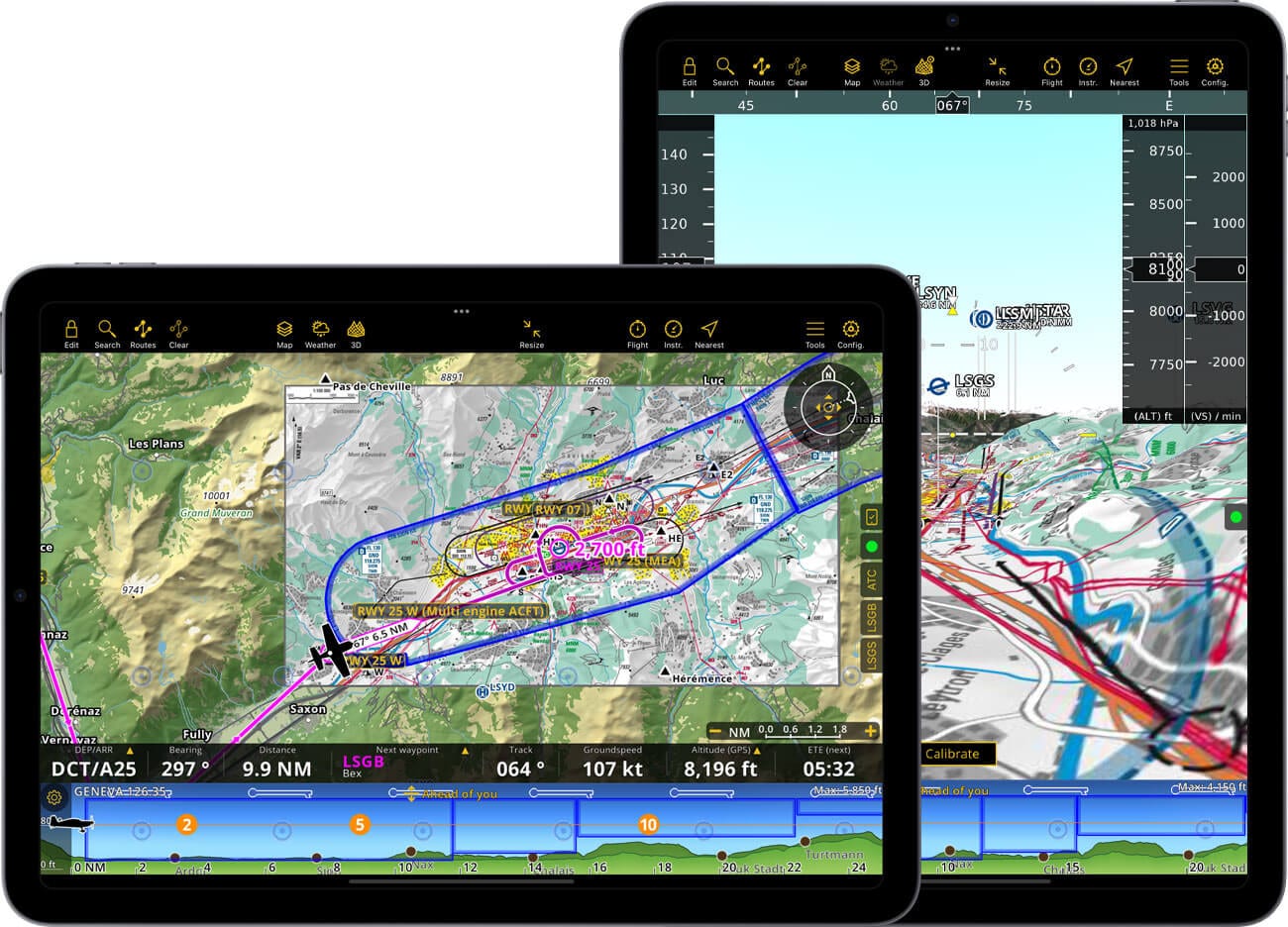
Anflugkarten
- Georeferenzierte Flughafenanflugkarten erscheinen automatisch auf dem Abflug- und Zielflughafen Ihrer geplanten Route
- AIP-Dokumente können nach Flugplatz Ihrer Wahl durchsucht werden
- Drucken von AIP-Dokumenten
Wetter (in alle Premium Pakete inbegriffen)
- Überprüfen Sie die Wettervorhersage für bis zu 3 Tage im Voraus.
- Anzeige auf der Karte: Regenradar, Wind, Wolken und Regen, Gafor (CH und DE), Böen, Sichtweite und Druckmodule
- Die Wetterdaten werden über Ihre Internetverbindung ständig aktualisiert. Wettervorhersagen sind auch offline verfügbar.
- Wetterberichte sind im Briefing enthalten.
Höhenprofil und TAWS
- Folgen Sie Ihrer vertikalen Navigation in der Geländeprofilansicht
- Vermeiden Sie gesperrte Lufträume oder Gelände
- Vorausschauende oder geplante Routenmodi
Nacht Modus
- Die Benutzeroberfläche der Anwendung ist dunkel gestaltet
- Die bewegte Karte und das Höhenprofil können mit angepassten Farben für einen Nachtflug angezeigt werden
Verkehrsbewusstsein
- Integrierter Internetverkehr dank unserer Partnerschaft mit SafeSky *
- FLARM- und ADS-B-Unterstützung *
- Optische und akustische Warnungen
- ADS-L4Mobile-Unterstützung ***
* In allen neuen Smart-Abonnements enthalten
Flugaufnahme ermöglicht Ihnen Ihre Flüge zu speichern, indem jede Sekunde die GPS-, Höhen- und Geschwindigkeitsdaten des Fluges aufgenommen werden. Wieder zu Hause, können Sie Ihren Flugverlauf nochmals durchsehen und auf dem Moving Map analysieren oder als KML-Datei exportieren und in Google Earth ansehen. Teilen Sie Ihre Reise auch mit Freunde und Familie.
*** Bei Nutzung des integrierten SafeSky-Verkehrsdienstes nutzt Air Navigation Pro eine experimentelle Version von ADS-L4Mobile als Schnittstelle für den bidirektionalen Verkehrsaustausch. Ihre Position wird an über 15 Systeme gesendet, um die Sichtbarkeit zu maximieren.
Notizblock
- Öffnen Sie den Notizblock bequem mit drei Fingern, indem Sie von rechts nach links wischen
- Schreiben Sie Briefings, Frequenzen und ATC-Anweisungen mit Ihrem Finger
- Zur späteren Überprüfung werden dem Logbuch handschriftliche Notizen beigefügt.
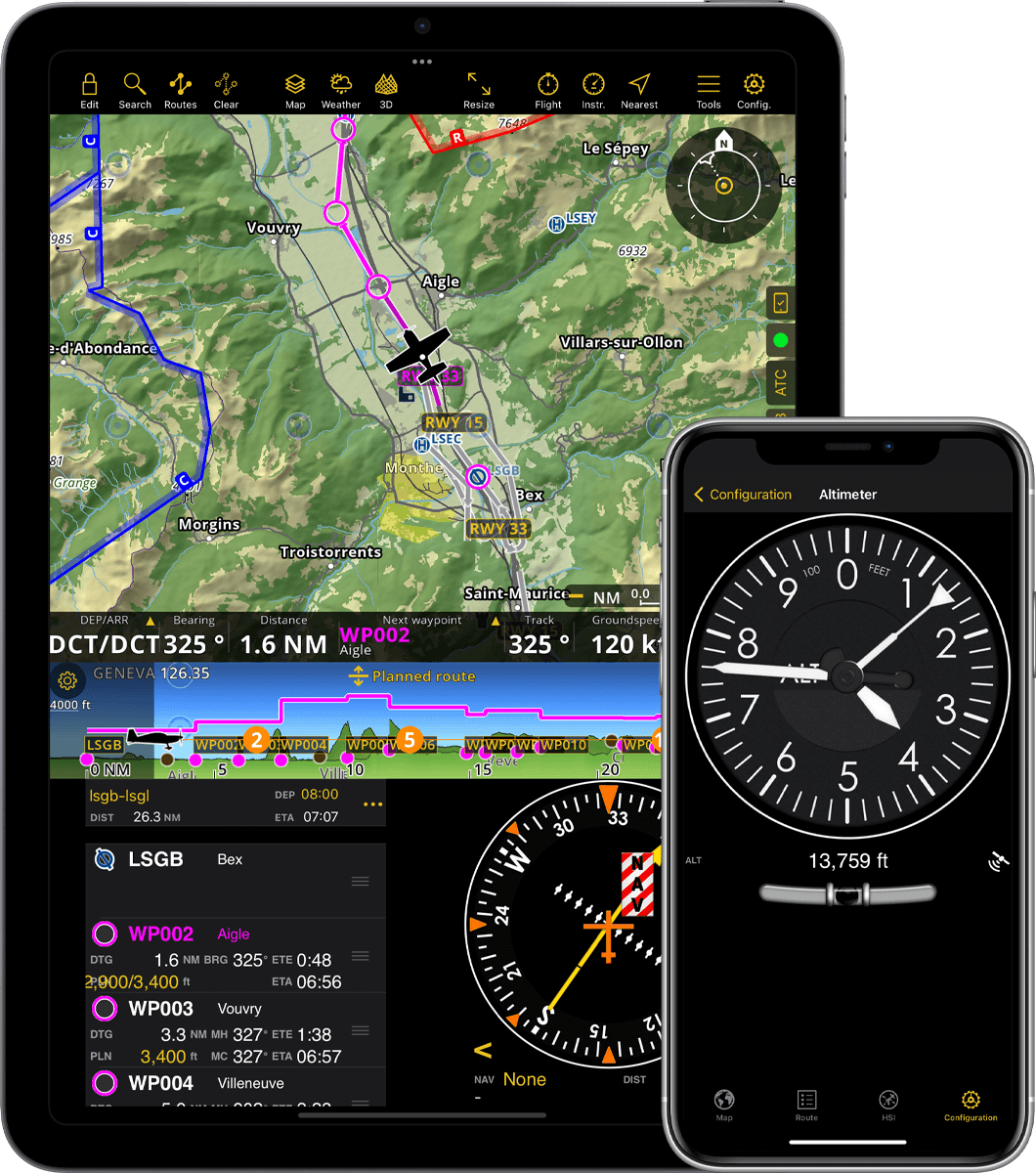
Fluginstrumenten
- Navigieren oder trainieren Sie mit verschiedenen flugzeugähnlichen Instrumenten
- Platzieren Sie HSI, RMI, Höhenmesser oder ein anderes Instrument auf dem Hauptbildschirm
- Greifen Sie jederzeit über das Menü auf jedes Instrument zu
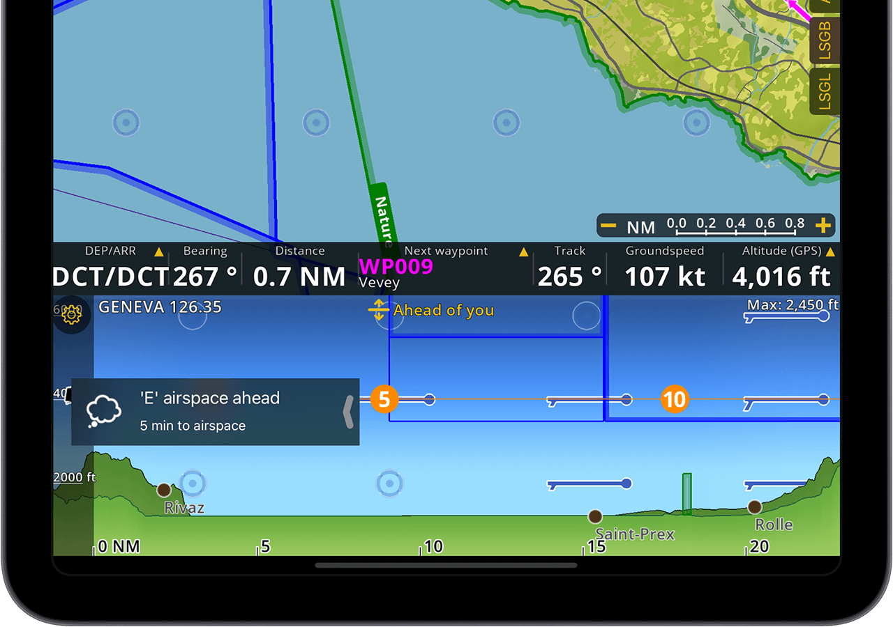
Warnungen
- Air Navigation Pro kann Sie beim Erreichen von Lufträumen informieren
- Vom Benutzer konfigurierbare Warnmeldungen beim Verlassen der geplanten Route oder beim Verlassen bzw. Erreichen der Flughöhe
- Wenn ein Datenbank-Update verfügbar ist, werden Sie durch eine Benachrichtigung informiert
Docks
- Direkter Zugriff auf Flughafeninformationen und Dokumente rund um Ihre Abreise und Ankunft
- ATC-Schublade berechnet eine Positionsmeldung aus Ihrem aktuellen GPS-Standort und anderen Flugparametern
- Die Statusleiste informiert Sie über Probleme mit den Hardwaresensoren oder der Konfiguration
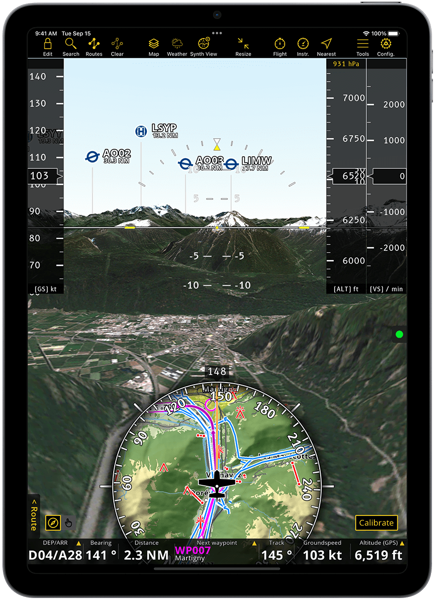
Synthetische Ansicht
- Synthetische Sicht mit Einstellung durch interne Gerätegyroskope und Beschleunigungsmesser
- Computergeneriertes 3D-Geländemodell basierend auf Satellitenfotos
- Schwenken Sie, um Standorte vor dem Anflug zu visualisieren
- Ausgestattet mit einem künstlichen Horizont und einer Moving Map-Vorschau sowie Anzeigen für Höhe, Bodengeschwindigkeit und vertikale Geschwindigkeit
- TAWS und Anflugkarten werden über die synthetische Ansicht gelegt
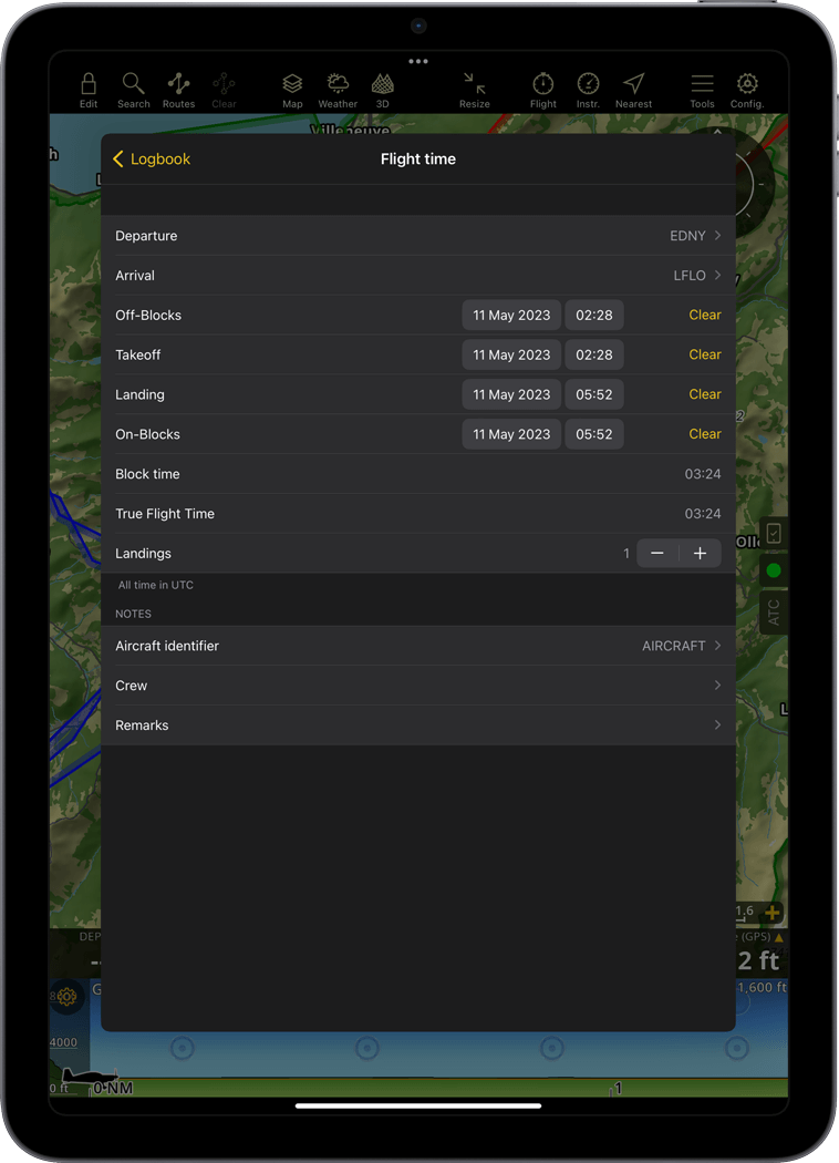
Automatisches Logbuch
- Block- und Flugzeiten sowie Abflug- und Zielflughäfen werden automatisch erfasst und im Logbuch gespeichert
- Das Logbuch kann bearbeitet werden, um fehlende Flüge hinzuzufügen oder Kommentare hinzuzufügen
- Senden Sie das Logbuch an Ihre E-Mail oder Ihren Computer
Flugaufnahme
- Flüge werden in einer Datenbank erfasst
- Anzeige der Flugspur in Echtzeit mit farbcodierten Geschwindigkeits- und Höhenänderungen
- Visualisieren Sie eine vorherige Flugspur auf der bewegten Karte
-
Teilen Sie den Flug in Echtzeit mit Ihren Freunden oder Ihrer Familie über das GSM-Netz*
Verwenden Sie die Flugaufnahme Funktion für VFR Trainings oder um Ihren Flug über soziale Netzwerke zu teilen
Flug abspielen
- Sehen Sie sich die Spur eines zuvor aufgezeichneten Fluges an
- Einen Flug wiederholen
Live Flugverfolgung teilen
- Teilen Sie Ihre aufgezeichneten Flüge mit Ihrem Konto oder per E-Mail
- Trace als KML- oder GPX-Dateien exportieren
Air Navigation Pro kostenlos testen
Verfügbar für iOS und Android. Klicken Sie unten auf den Shop und beginnen Sie mit der Nutzung der 28-tägigen kostenlosen Testversion