

Moving Map#
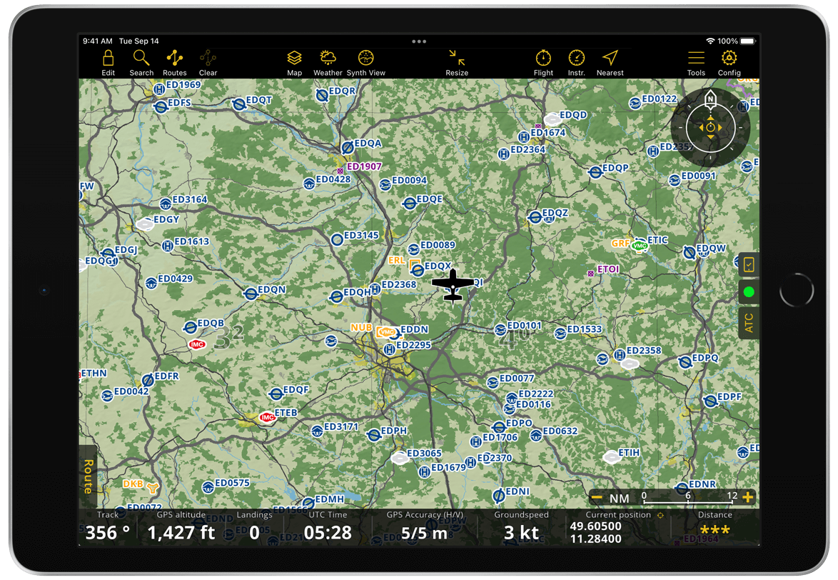
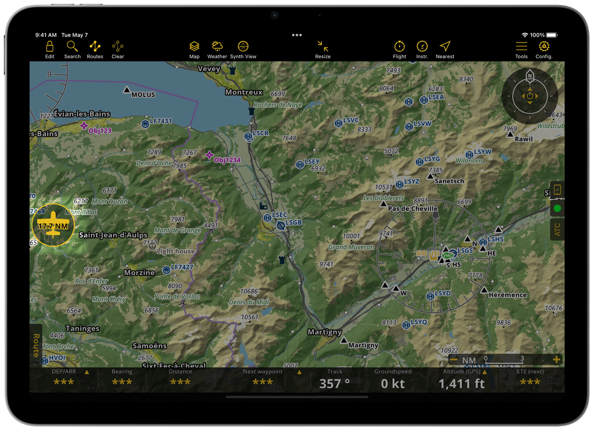
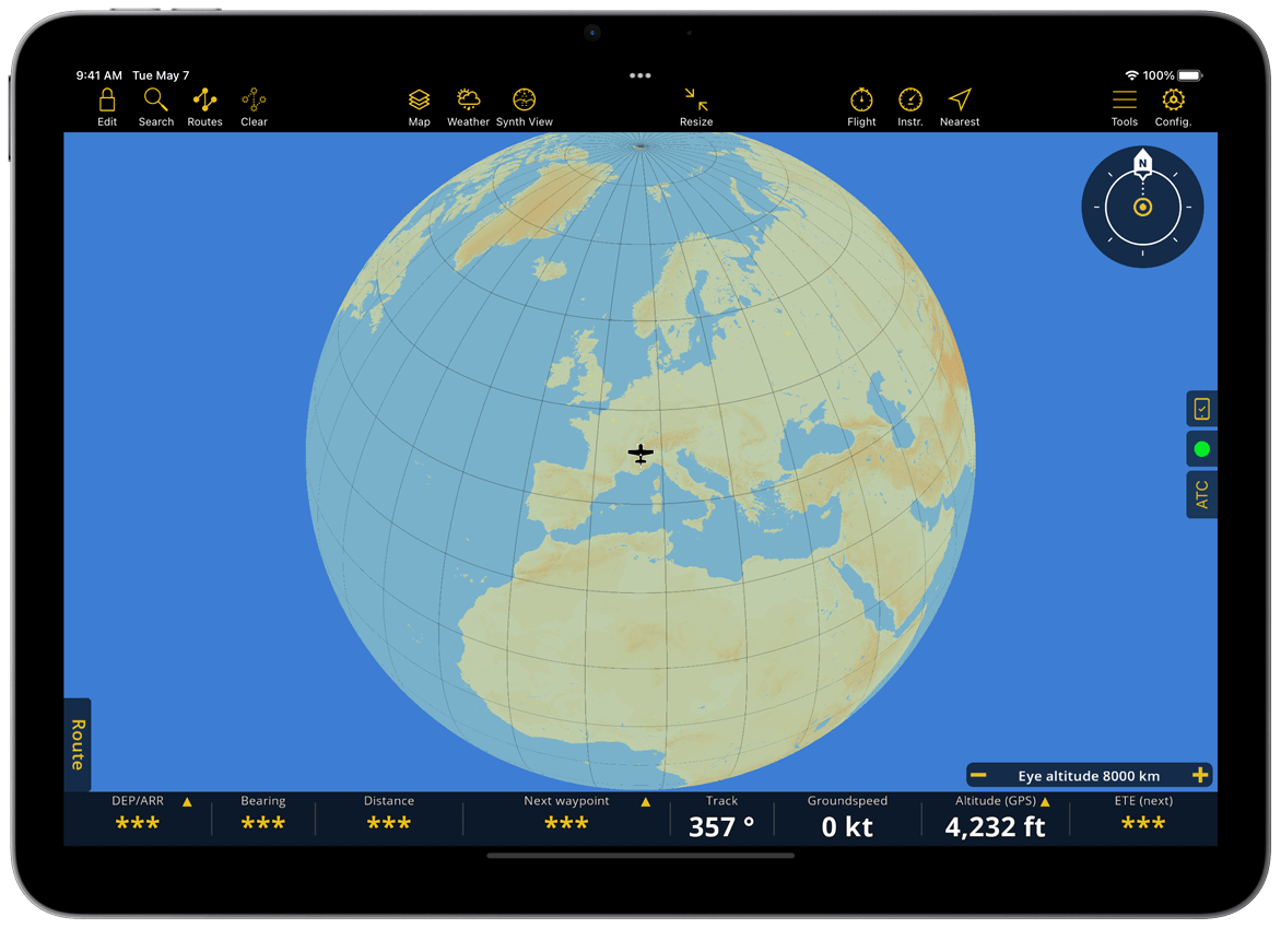
The Moving map is the heart of the application. It is where you spend most of the time interacting with Air Navigation Pro. It displays the necessary information to easily and safely plan your flight and navigate. Once you allow the application to access the device’s GPS, your location is shown on the map.
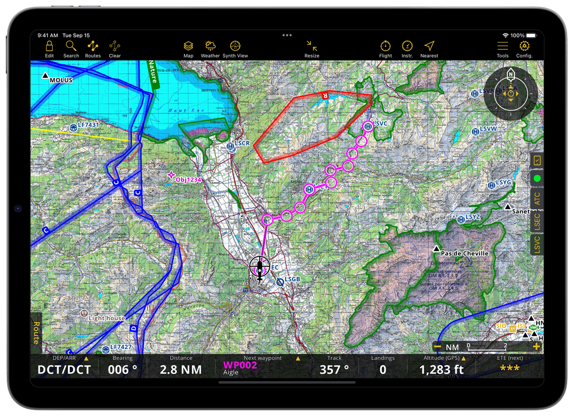
On the Moving Map you can see the following:
SmartChart (Terrain, cities, roads, landmarks, rivers, lakes)
You can also see other aircrafts when your mobile device is connected to the Internet, to an ADS-B or FLARM Module.
Aeronautical Data#
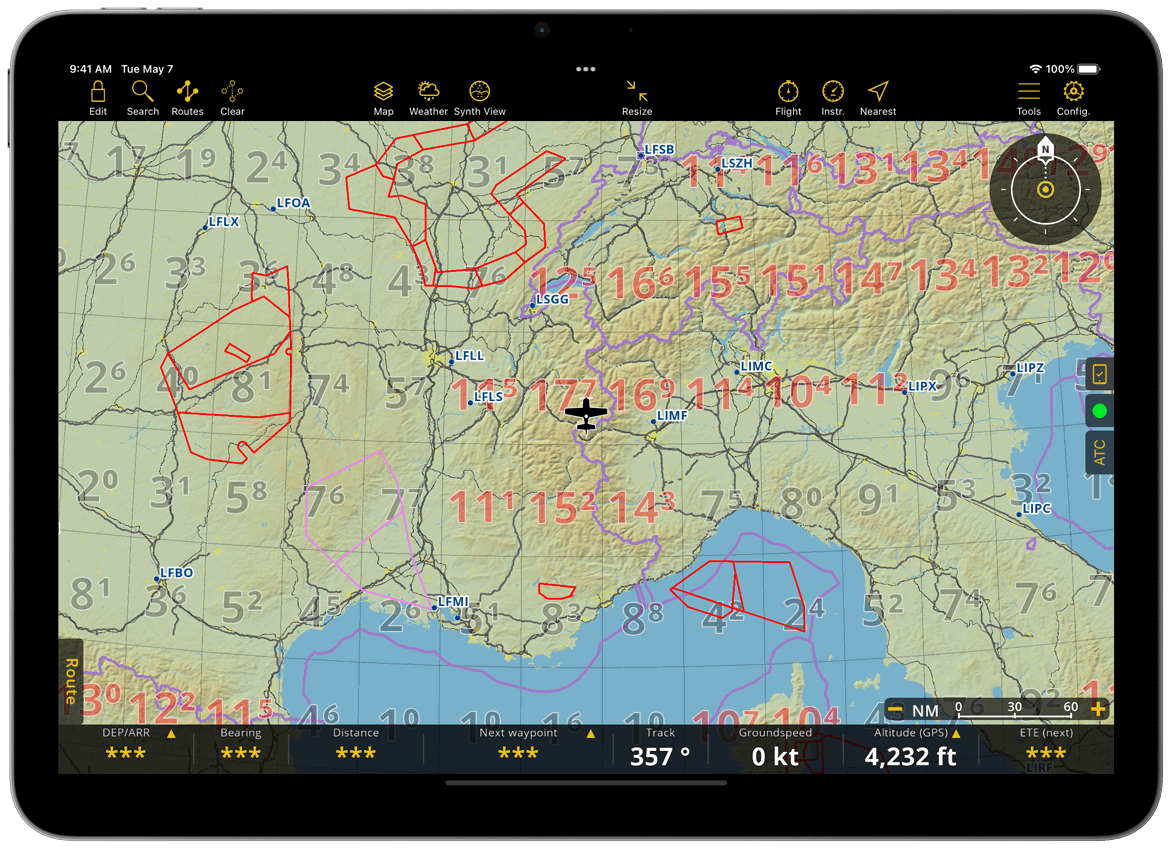
Airspaces#
Our extensive aeronautical database, included in any subscription and updated every 28 days following the AIRAC cycle, offers more than 65,000 airspaces of different classes, covering the entire world. You can install and update it in Configuration > Manage Data and Products. We recommend enabling automatic updates to ensure you always fly with the latest aeronautical information.
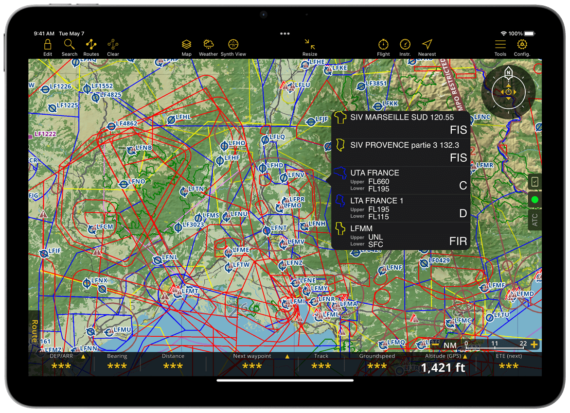
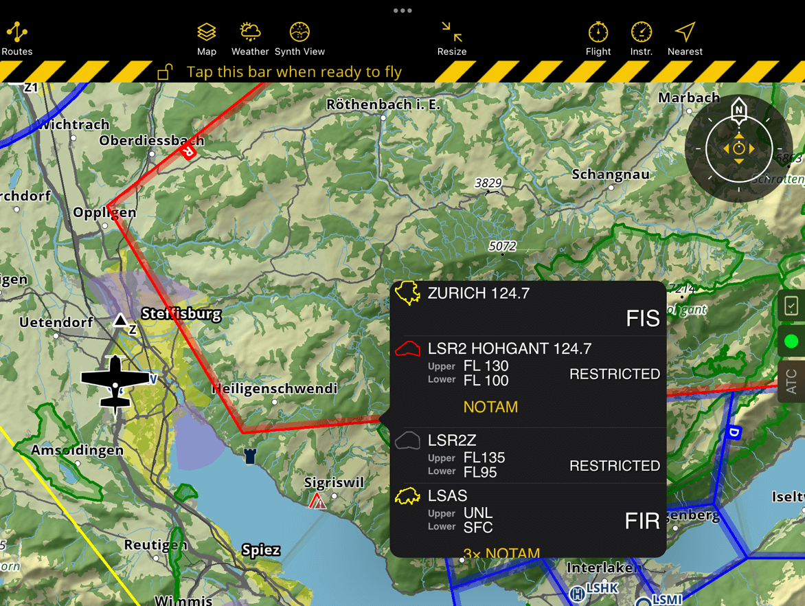
Tapping any object (airspaces, waypoints, NOTAM, Obstacles) on the map displays a popover with detailed information for that object. The selected object is highlighted both on the map and in the popover.
Note
Highlighted objects in the popover have a gray background, while unhighlighted objects have a black background.
Hint
To remove the highlight from an object on the map, tap the object directly the map or tap its corresponding item in the popover.
Airspaces have different colors based on their class. Below is the color legend to help you quickly identify each airspace class on the map:
Airspace Class |
Color |
A, B, Danger, Prohibited, Restricted, MATZ (MIL) |
Red |
C, D, E, F, CTR & Recreational |
Blue |
TMZ & Custom Airspaces |
Black |
TSA, TRA |
Pink |
Nature Reserve |
Green |
G, FIS & FIR |
Yellow |
Airspaces can be activated or deactivated via a NOTAM. Air Navigation Pro reflects these status changes with color. When inactive, the airspace will be shown in gray. If an airspace will become active within the next 24 hours, it will appear in its original color but with reduced opacity. Once activated, it will be displayed in its full color.
Hint
During Route Planning, you can set a departure time in the future and the map will show the activation status of airspaces for the time of your flight.
Following aeronautical chart design standards, airspaces are displayed with a label showing their class, floor and ceiling:

Some restricted airspaces are activated through EAUP (European Airspace Use Plan) publications. Air Navigation Pro displays these airspaces using color codes, but their status depends on how each country manages activation:
In countries like Switzerland and France, many restricted airspaces are inactive by default and are activated by NOTAM.
In contrast, in countries like Germany, certain restricted airspaces are active by default and can be deactivated by NOTAM.
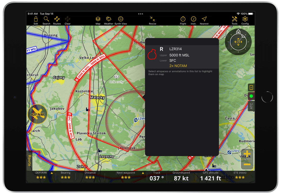
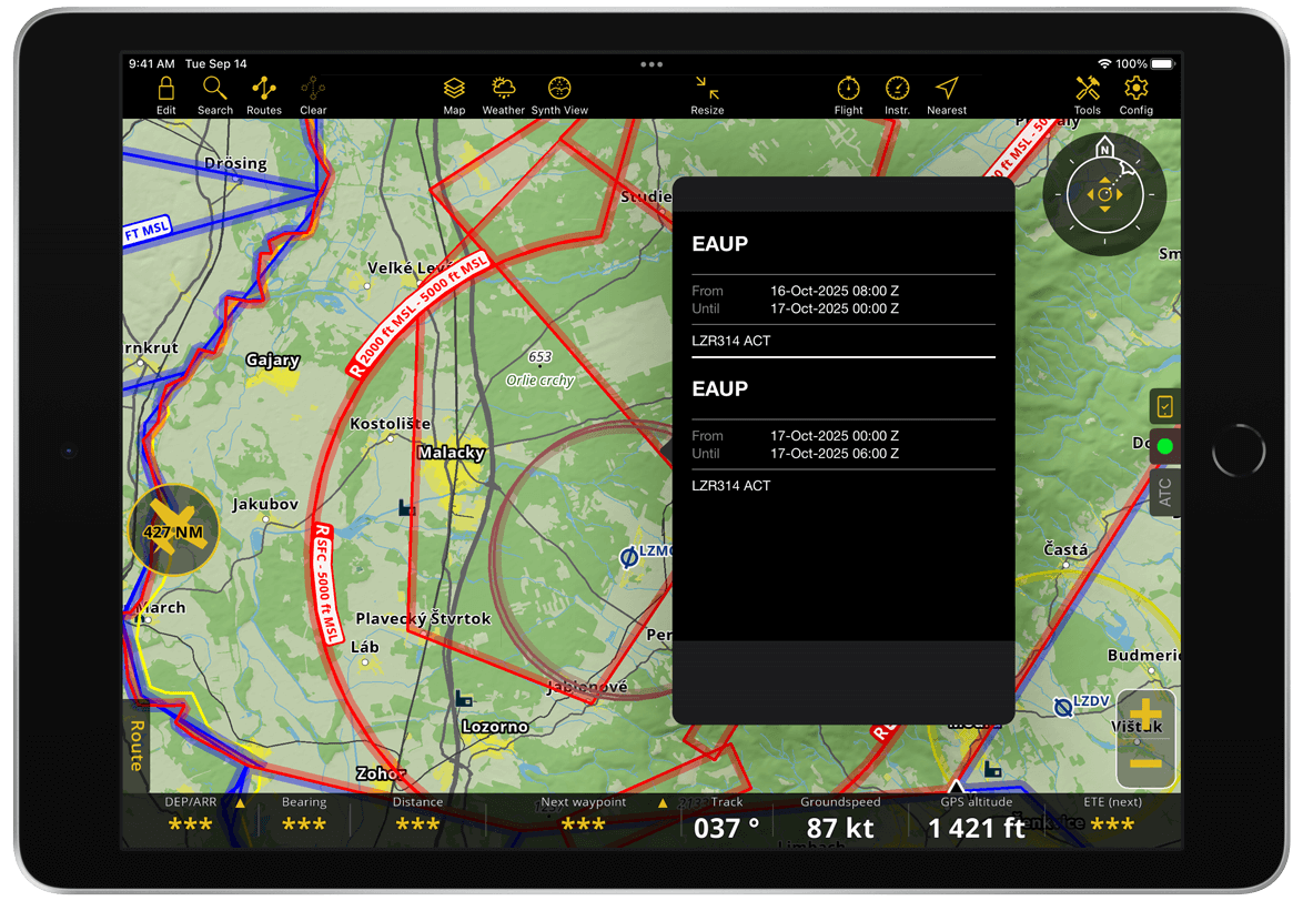
Tapping the interactive NOTAM text allows the user to check whether the airspace activation originates from an EAUP.
Note
EAUP publications can only activate airspaces, they cannot deactivate them. Always check relevant NOTAMs for the latest airspaces status.
You can manage the display of airspaces in the Moving Map via Map Options > Airspaces. You can also display airspaces in the Profile View.
Waypoints#
Air Navigation Pro gives you access to over 210,000 waypoints worldwide, which are displayed on the map for easy route planning. You can easily Search for and add these waypoints to your route. Access to the waypoint database requires an active subscription. The database is updated every 28 days, in accordance with the AIRAC cycle. In the Map options menu, you can view all available waypoint types and customize which types of waypoints are displayed or hidden on the map.
Note
Closed waypoints are still displayed on the map as  icon and without an ID. They remain tappable, allowing you to view their details in the waypoint popover. Go to Waypoints to manage its display on the map.
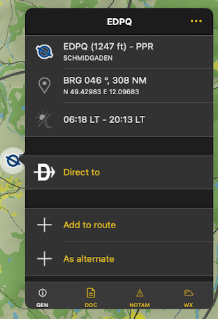
Waypoint popover#
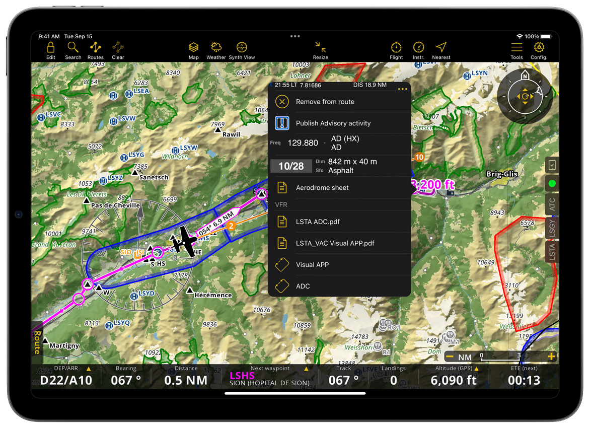
Tapping on any waypoint on the map will display its details, including essential information and available actions. These are organized into the following tabs for easy reference: GEN (General), DOC (Documentation), NOTAM, and WX (Weather).
Note
Tabs that do not contain any available data are automatically hidden from view. The NOTAM tab, however, remains visible at all times to allow users to publish advisories.
![]()
GEN - The General tab displays the information about the selected waypoint, including:
Waypoint details - Displays the waypoint identifier (ICAO code), name, and airport elevation.
Waypoint location - Shows the bearing and distance from your current location, along with the waypoint’s geographic coordinates.
Sunset and Sunrise time - Provides the local times for sunrise and sunset at the selected waypoint.
Direct to - Creates an immediate route from your current GPS position to a selected waypoint on the map.
Add to route button - Allows you to easily add the selected waypoint to your route.
Remove from route - Removes the selected waypoint from your current route.
As alternate - Marks the selected waypoint as an alternate airport for your route, allowing quick diversion planning.
Instructions button - Opens additional options such as planned altitude, landing instructions, and SAR (Search and Rescue) pattern for the selected waypoint. This is displayed when edit mode is enabled.
Frequency (optional) – shows the radio frequency or channel used by the navaid to transmit signals for aircraft navigation.
Runways - Lists the available runways at the selected waypoint. Tapping on any runway will display additional details specific to that runway. If the waypoint is part of your route, a procedure selector will also appear in the runway information window.
Radionavigation beacons - At the bottom of the General tab, a list of radio navigation beacons (if available) is displayed. These beacons are VOR-type navaids within a 40 NM radius of the selected waypoint. Tapping on any beacon will provide additional information and available actions related to that beacon.
Note
The placement and available actions in the GEN tab will change depending on the active mode (Edit Mode or Flight Mode).
DOC - In the Document tab, you can install related products on demand if your account includes an approach chart for the selected waypoint. Once installed, all documents and charts will appear in this tab, organized by category.
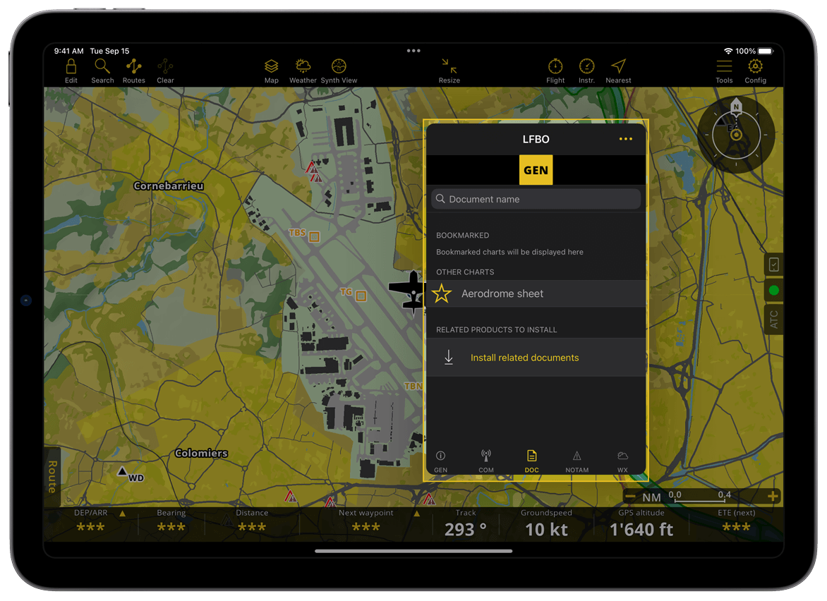
You can browse documents in each category or use the search feature for quick access. Each document has a ![]() icon next to it, and some may also display a
icon next to it, and some may also display a ![]() icon. Tapping the
icon. Tapping the ![]() icon will easily display them on the moving map while keeping the popover open. On phones, a toast message will confirm the chart is displayed. Now, the
icon will easily display them on the moving map while keeping the popover open. On phones, a toast message will confirm the chart is displayed. Now, the ![]() icon has been replaced by
icon has been replaced by ![]() .
.
You can bookmark any document from different categories as a favorite by tapping the ![]() icon. It will be saved in the Bookmarked section, which appears in every category and subcategory.
icon. It will be saved in the Bookmarked section, which appears in every category and subcategory.
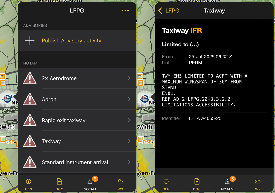
NOTAM - In the NOTAM tab, you can publish advisory activities at the same location as the selected waypoint. This tab also displays a badge indicating the number of active and upcoming NOTAMs associated to the selected aerodrome. Tapping on a NOTAM will reveal its essential details and information.
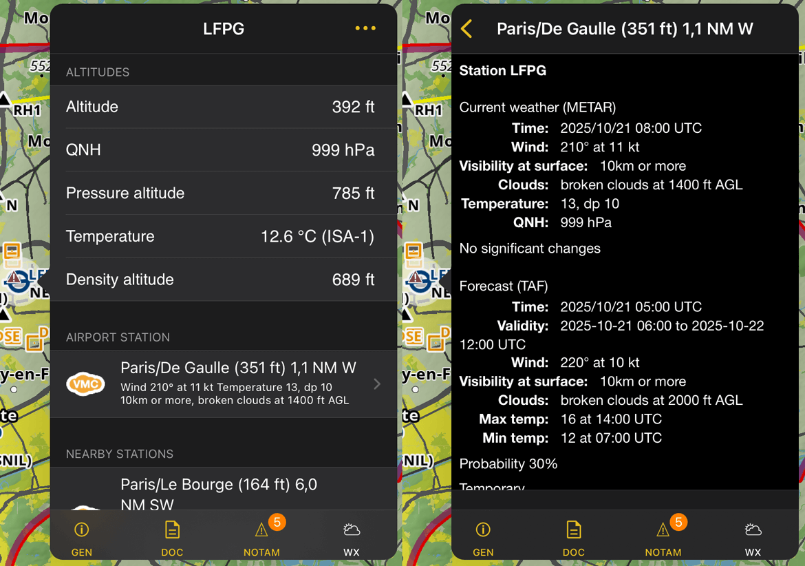
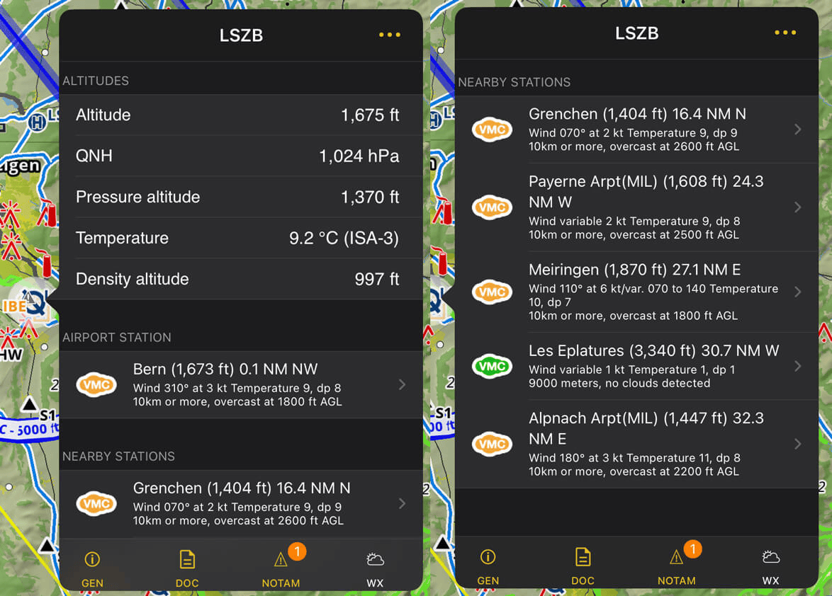
WX - The Weather tab displays the selected waypoint’s altitude, atmospheric pressure, and temperature, along with a list of nearby weather stations. Tapping on a weather station will display its current and forecasted weather report.
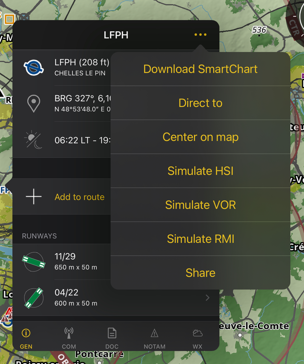
More options are available in the waypoint popover, including downloading the SmartChart for the selected waypoint for offline use, directing a route from your location to the selected waypoint, centering the waypoint on the map, simulate instrument, and sharing the waypoint in GPX format or via a Google Maps link. Simply tap the ![]() to access these options.
to access these options.
Weather stations#
Air Navigation Pro displays on the map reliable weather stations that are regularly updated. Tapping on the weather icon displays the weather information.
- The Weather tab is divided into three sections: Altitudes, Airport Station, and Nearby Stations.
The Altitudes section shows the elevation of the selected waypoint.
The Airport Station section displays weather data from the aerodrome’s on-site weather station.
The Nearby Stations section lists surrounding weather stations, including their elevation, distance and direction from the selected airport.
- METAR/TAF stations have different coloured cloud icons which are to let you know about the flying condition:
 Green with “VMC” - VMC - Visual Meteorological Conditions (VFR allowed).
 Amber with “VMC” - Marginal - VMC (Close to the limit for a VFR flight).
 Red with “IMC” - Instrument Meteorological Conditions (Only IFR flights).
 Black with “TAF” - No METAR but has TAF data.
 Grey with “-” - No data/network available or loading in progress.
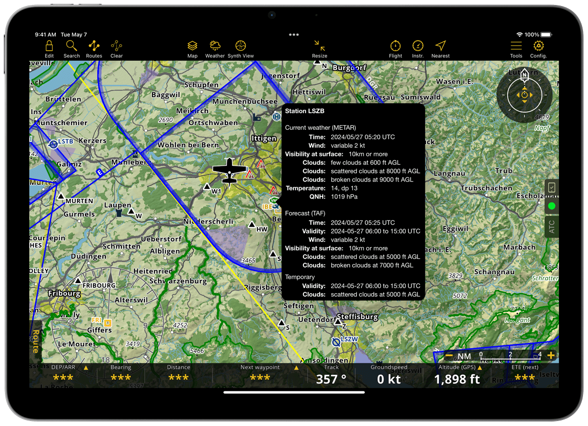
Air Navigation Pro reads the METAR and TAF and shows them in a user-friendly readable format. You can see the raw METAR/TAF by enabling the option “Raw METAR/TAF” under Configuration > Settings > MISC.
NOTAM#
Air Navigation Pro provides NOTAM (Notice to Air Missions) information with all subscription plans.
NOTAM are continuously updated when you are online. Active NOTAM are highlighted in brown on the map.
Not all NOTAM are displayed on the map. The app filters less relevant NOTAM to show only the most pertinent information. All NOTAM remain available in the preflight briefing (see NOTAM).
By default, NOTAM with a distant activation time are hidden. You can adjust the display period in Map Options > NOTAM.
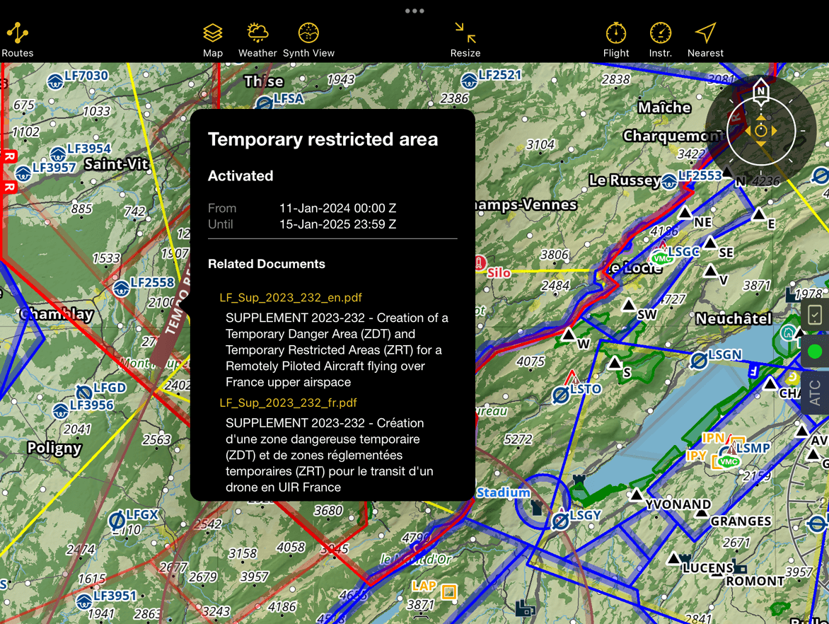
Tap a NOTAM on the map to view detailed information. Some NOTAM include attached documents (e.g. SUP), which can be opened directly in the app.
You can also show or hide NOTAM in the Profile View.
Types of NOTAM#
With their exact shape#
When the NOTAM geometry is available, it is displayed accurately on the map. If the geometry cannot be determined and the radius is small, the NOTAM is displayed as a circle centered on its position.
NOTAM belonging to an aerodrome#
These NOTAM are displayed using a triangular icon with an exclamation mark.
For example, a runway-related NOTAM is attached to the aerodrome icon. To view details:
Tap the aerodrome
Open the NOTAM tab in the waypoint popover
A badge shows the number of associated NOTAM.
Note
If no NOTAM are available, the tab and badge are not displayed.
![]()
NOTAM belonging to an airspace#
If a NOTAM is associated with an airspace, it may be displayed directly within that airspace instead of as a surrounding circle.
Tap the airspace to view detailed NOTAM information.
Note
NOTAM may affect the activation status of Restricted and Danger airspaces. During flight planning, the app updates airspace colors dynamically based on the selected Departure Time. See Route Planning.
For obstacles#
Obstacle-related NOTAM are displayed as obstacles with a NOTAM icon.
NOTAM that point to documents#
Some NOTAM include attached documents. These can be opened directly from the NOTAM popover.
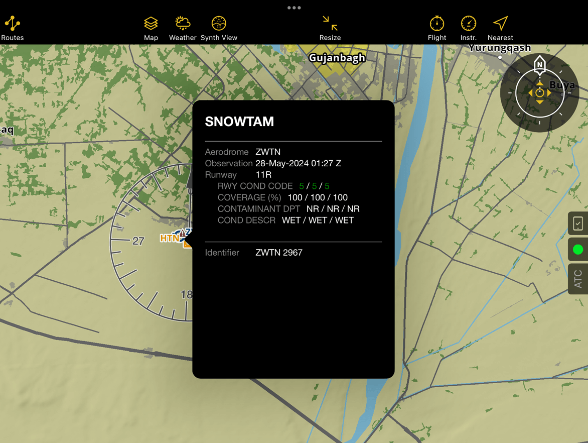
SNOWTAM & ASHTAM#
The application also supports and displays SNOWTAM and ASHTAM with their details on the map.
Note
You can manage NOTAM categories in Map Options > NOTAM.
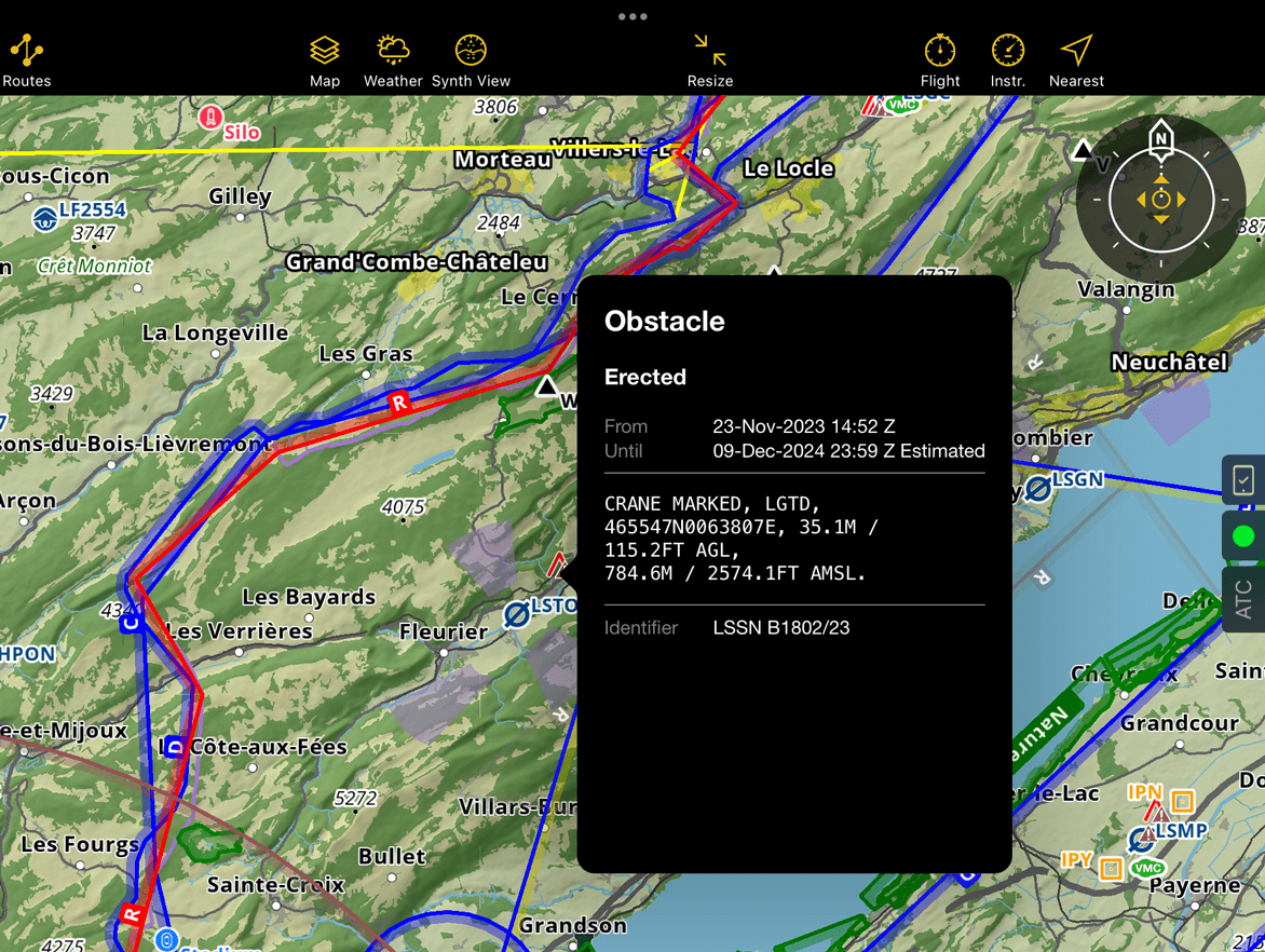
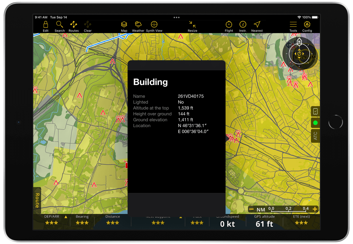
Obstacles#
We offer a wide-ranging obstacle database for selected countries as part of our Subscription plans. The database is updated weekly to ensure you have the latest obstacle information available for your flight. You can install the obstacles database from Manage Data and Products. The display of obstacles on the Moving Map can be managed in Map Options > Obstacles.
To view obstacle details on the Moving Map, zoom in until the obstacle symbol is clearly visible, then tap it to display more information. If several obstacles are close together, they appear as a cluster. Tap the cluster and select an obstacle to view its details.
You can also display obstacles on the Profile View.
Types of obstacles#
Points#
Obstacle points are represented by icons. To avoid cluttering at lower zoom levels, only one icon will be displayed even if multiple obstacles are located in the same area. Zooming in will display more detailed information for each individual obstacle in that area.
Icon
Meaning
Icon
Meaning
300 ft Obstacle
Wind Turbine
300 ft Obstacles
Wind Turbine Lighted
300 ft Lighted Obstacle
Power Pole
300 ft Lighted Obstacles
Chimney
500 ft Obstacle
Tank
500 ft Lighted Obstacle
Church
Tower
Factory
Lighted Tower
Mountains
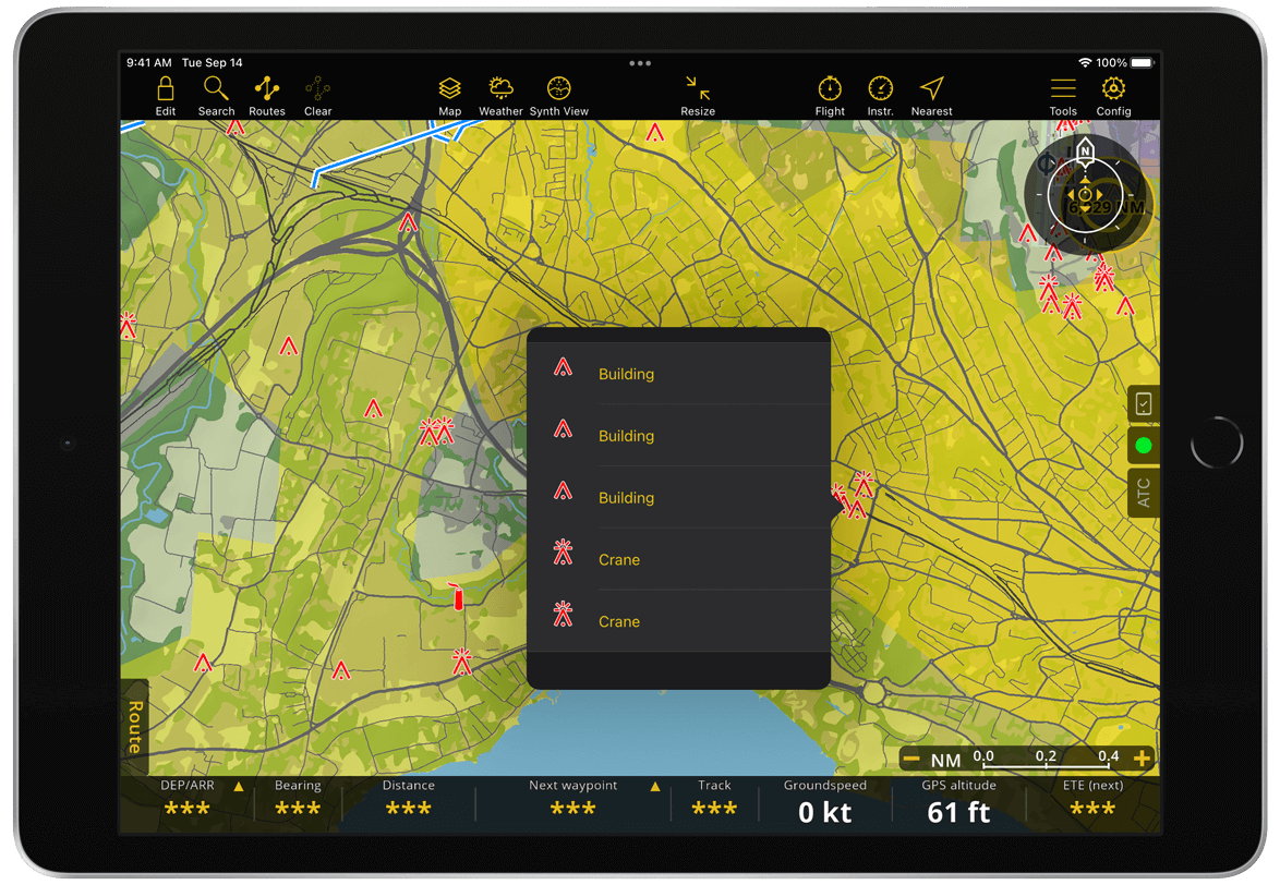
Lines#
The app does not offer decluttering for lines, so obstacle lines are not visible at lower zoom levels. Once you zoom-in enough to allow a clean display, they will be displayed. For Norway, you can color power lines based on their height from ground in Map Options > Obstacles.
Colored power lines.
Surfaces#
Obstacle surfaces are not very common. They are displayed on the map as areas with a red border and clearly labeled as Obst. An example of an obstacle surface is an area with several wind turbines, which is displayed as a single marked area instead of identifying each turbine as obstacle individually.
User Data#
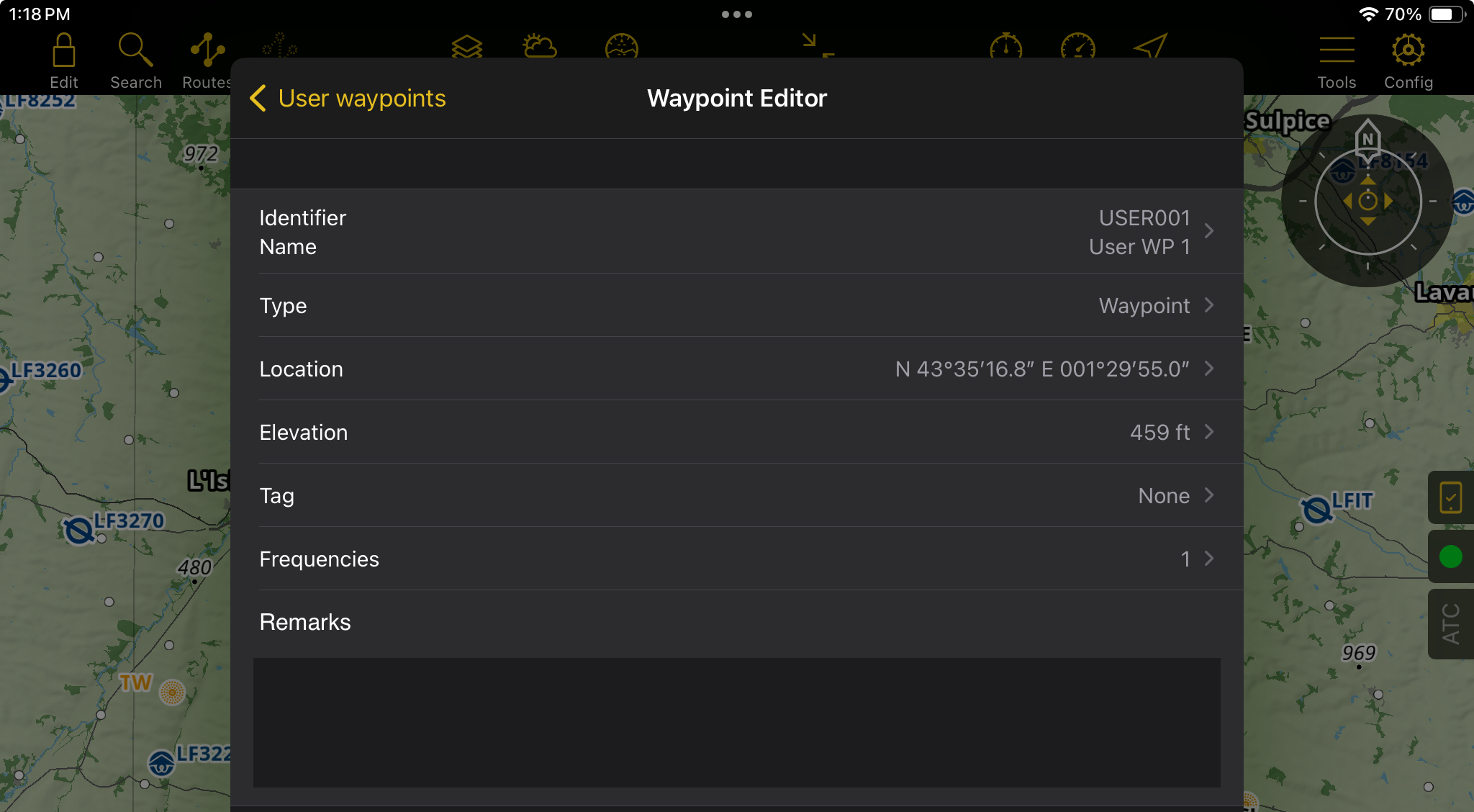
User Waypoints#
In addition to the Waypoints provided from the worldwide aeronautical database, Air Navigation Pro offers the possibility to create and import your own waypoints, referred as ‘User waypoints’. You can easily manage, back up, and restore these waypoints through the Tools menu.
Create via the Moving Map#
Press and hold on the map at the location where you want to create the user waypoint.
Tap the Create user waypoint button.
The app will automatically populate the waypoint details, but you can modify them by tapping the fields you wish to edit.
Tap Done in the top right corner to save.
The user waypoint will now be displayed at the location you selected on the map.
Create via Tools#
Navigate to Tools > User waypoints.
Tap the + Add a new waypoint button.
The app will automatically populate the details based on your current location, but you can edit any field by tapping on it.
Once finished, tap User Waypoints (tablet version) or Back (mobile version) to save your waypoint.
The newly created user waypoint will appear at the map location you specified.
Note
Except for the waypoint name, tag, and remarks, all other fields are mandatory and cannot be left blank.
Create via URL#
Air Navigation now allows you to add waypoints or routes directly from a link, making it easier to share navigation data by email, SMS, or web page. Simply tap a specially formatted link, and the app will automatically open and load the waypoint(s) or route.
You can use direct links to perform the following actions in Air Navigation:
Direct To: Instantly navigate to a specific waypoint.
Add Waypoints: Import one or more waypoints into your custom database.
Create Route: Create and load a complete route with multiple waypoints.
How the URL Works
A direct link follows this basic structure:
airnavpro://<action>?<query>
Example
Clean (readable) version:
airnavpro://direct-to?coordinates=wgs84-decimal&location=46.875_7.234,0.0,WP1,Grass field
Encoded (web-safe) version:
airnavpro://direct-to?coordinates%3Dwgs84-decimal%26location%3D46.875_7.234%2C0.0%2CWP1%2CGrass%20field
The link contains:
Scheme: airnavpro:// (tells the system to open Air Navigation)
Action: direct-to, add-waypoints, or new-route
Query: the data part (coordinates, waypoint info, etc.)
Note
Important: The query part must be URL encoded if it includes special characters.
Coordinates are defined in the query using:
coordinates=<format>
Supported formats include:
wgs84-ddmmss
wgs84-decimal
wgs84-ddmmdecimal
utm-std, utm-band, ups
mgrs100, mgrs10, mgrs1
swiss, uk, rt90, sweref99tm, etc.
Each waypoint is described as a list of values separated by commas ( , ):
<coordinates>, <elevation>, <identifier>, <name>
If there are several waypoints, separate them with semicolons ( ; ).
Because some coordinate formats use spaces, coordinate components are joined with underscores ( _ ).
Example (WGS84 Decimal)
46.875_7.234,0.0,WP1,Grass field
Position Description Example:
Coordinates 46.875_7.234
Elevation (meters) 0.0
Waypoint identifier WP1
Waypoint name (optional) Grass field
Direct To a Waypoint#
Use this format:
airnavpro://direct-to?coordinates=<format>&location=<waypoint>
Example:
WGS84 Decimal:
airnavpro://direct-to?coordinates=wgs84-decimal&location=46.875_7.234,0.0,WP1,Grass field
WGS84 DMS (Degrees, Minutes, Seconds):
airnavpro://direct-to?coordinates=wgs84-ddmmss&location=N 12°34′56″_W 78°12′34″,0.0,WP1,Grass field
Swiss Grid (CH1903):
airnavpro://direct-to?coordinates=swiss&location=602030.68_191775.03,0.0,WP1,Zimmerwald
Add Waypoints to Your Database#
Use this format:
airnavpro://add-waypoints?coordinates=<format>&waypoints=<point1>;<point2>;<point3>
Example:
airnavpro://add-waypoints?coordinates=wgs84-decimal&waypoints=46.123_6.543,125.0,WP1,Grass field;47.113_7.143,225.1,WP2,Forest;45.153_6.643,1225.0,WP3,Antenna
This will add all three waypoints to your user waypoint database.
Create a Route#
Use this format:
airnavpro://new-route?coordinates=<format>&route-name=<name>&waypoints=<point1>;<point2>;<point3>
Example:
airnavpro://new-route?coordinates=wgs84-decimal&route-name=myRoute&waypoints=46.123_6.543,125.0,WP1,Grass field;47.113_7.143,225.1,WP2,Forest;45.153_6.643,1225.0,WP3,Antenna
This will create and load a route named myRoute in Air Navigation.
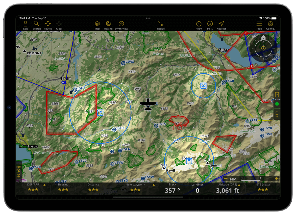
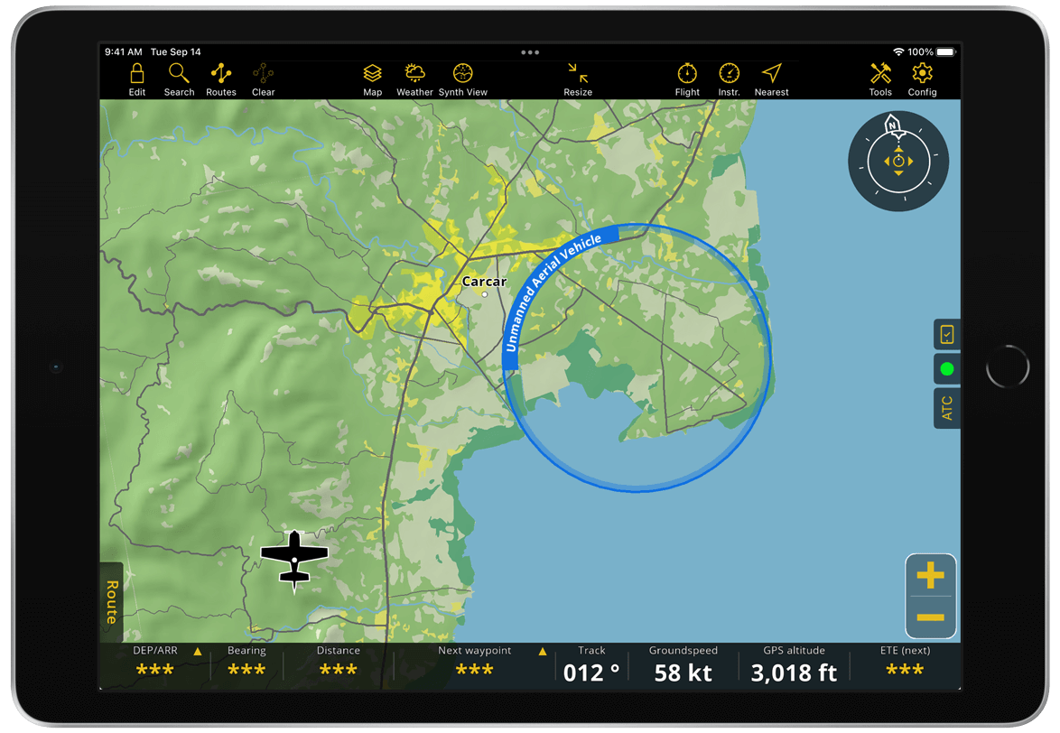
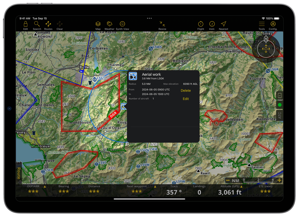
Advisories#
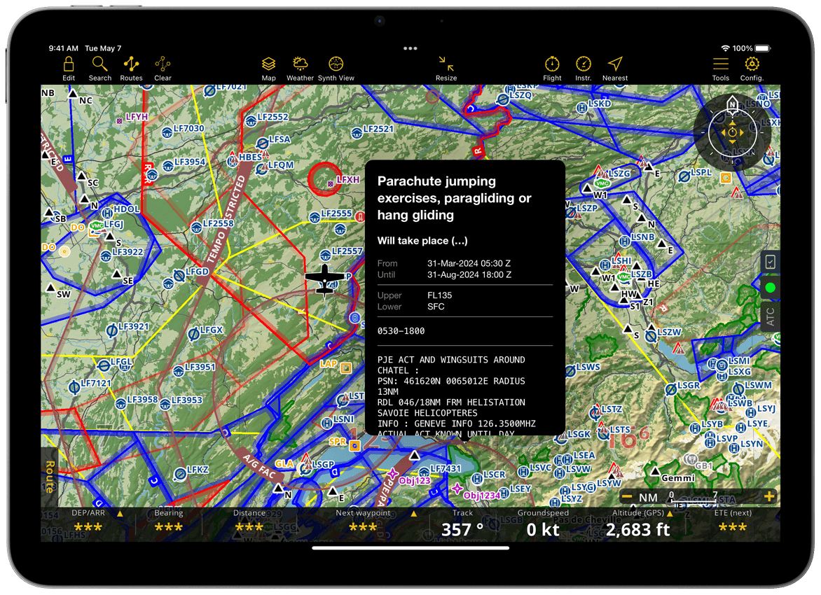
Air Navigation Pro allows you to view advisories published by other users and publish your own to share information about special activities in the sky.
Note
Air Navigation Manager customers can create and edit advisories through the web service. However, polygon-shaped advisories can only be created in Air Navigation Manager.
Publish Advisories#
An Air Navigation account is required to publish an advisory activity.
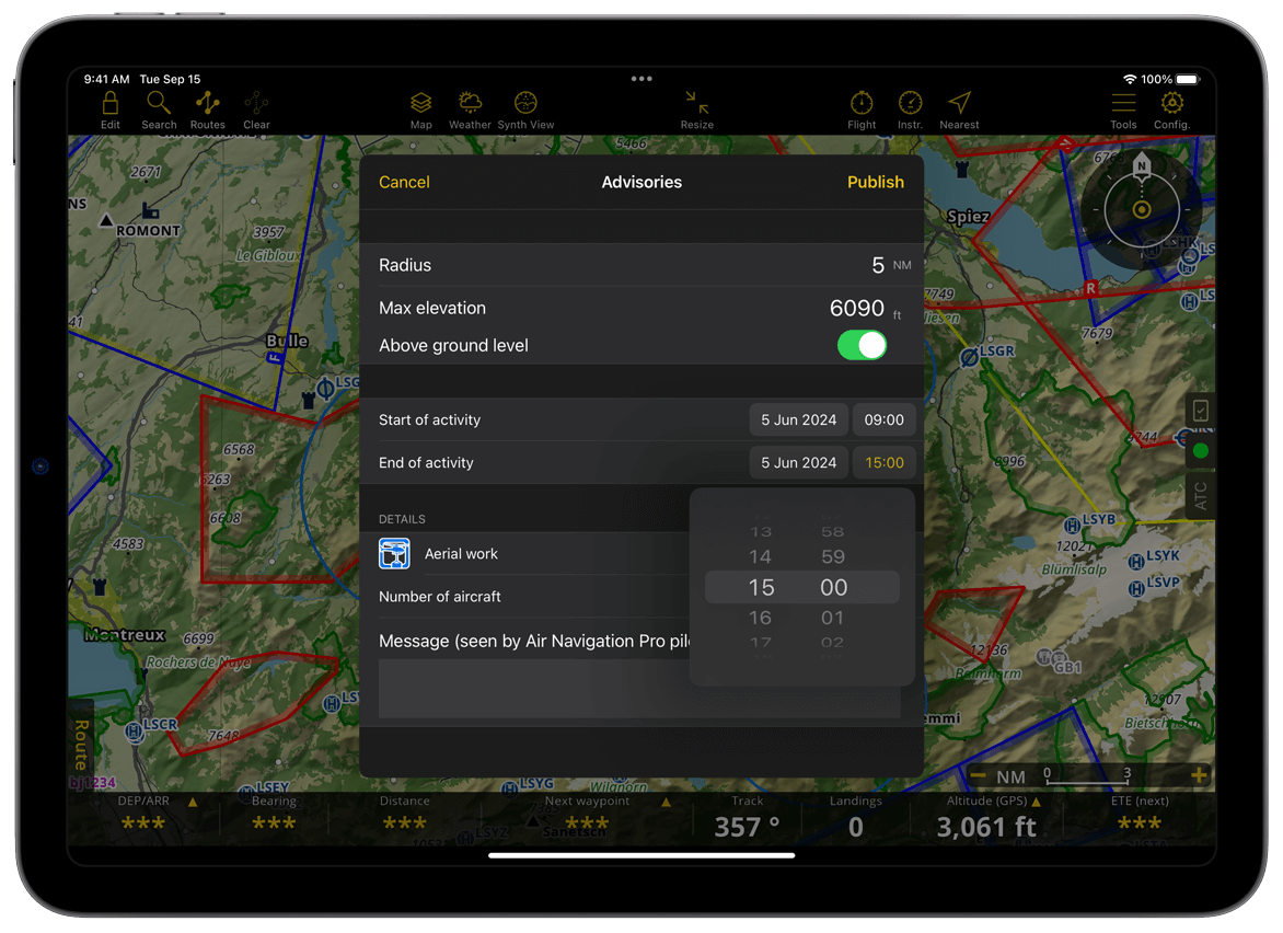
Move the map to the location where you want to create an advisory.
Tap a waypoint or press and hold the desired location on the moving map.
From the waypoint popover, go to NOTAM tab.
Tap Publish Advisory activity.
Provide all necessary information on the Advisory window: Radius, Max elevation, Start and End of activity, Type of advisory, Number of aircraft and Message.
Tap Publish.
After publishing an advisory, a blue circle labeled with the selected activity type will appear on the map.
Note
You may need to zoom in on the map to see the advisory activity type label.
Life cycle#
Advisories remain visible on the map until they expire. Active advisories are shown in blue, while upcoming (not yet active) advisories appear in gray.
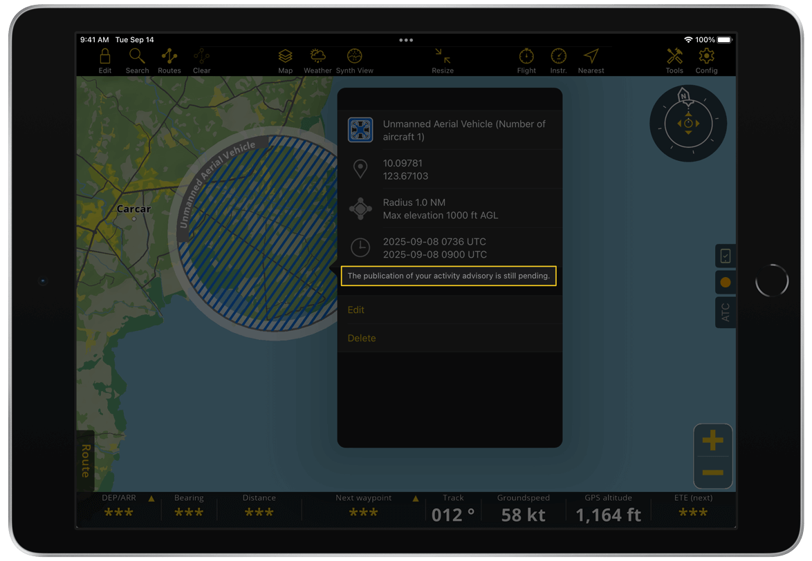
Edit Advisory activity#
You can only edit your own advisories.
Tap the advisory activity on the map.
Tap Edit on the popup window.
Edit the details you want to update.
Tap Publish.
Delete Advisory activity#
You can only delete your own advisories:
Tap the advisory activity on the map
Tap Delete
Pending advisory#
Pending advisories are advisories you created while offline. They are shown on the map as circle with a blue dashed fill and remain stored in the app until they are published automatically once an internet connection is available.
Note
You can manage the display of advisories on the map in Map Options > Advisories.
Map Annotations#
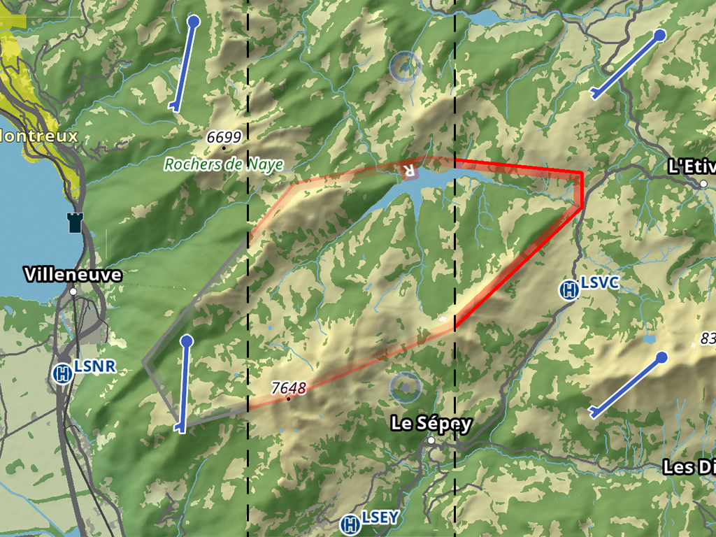
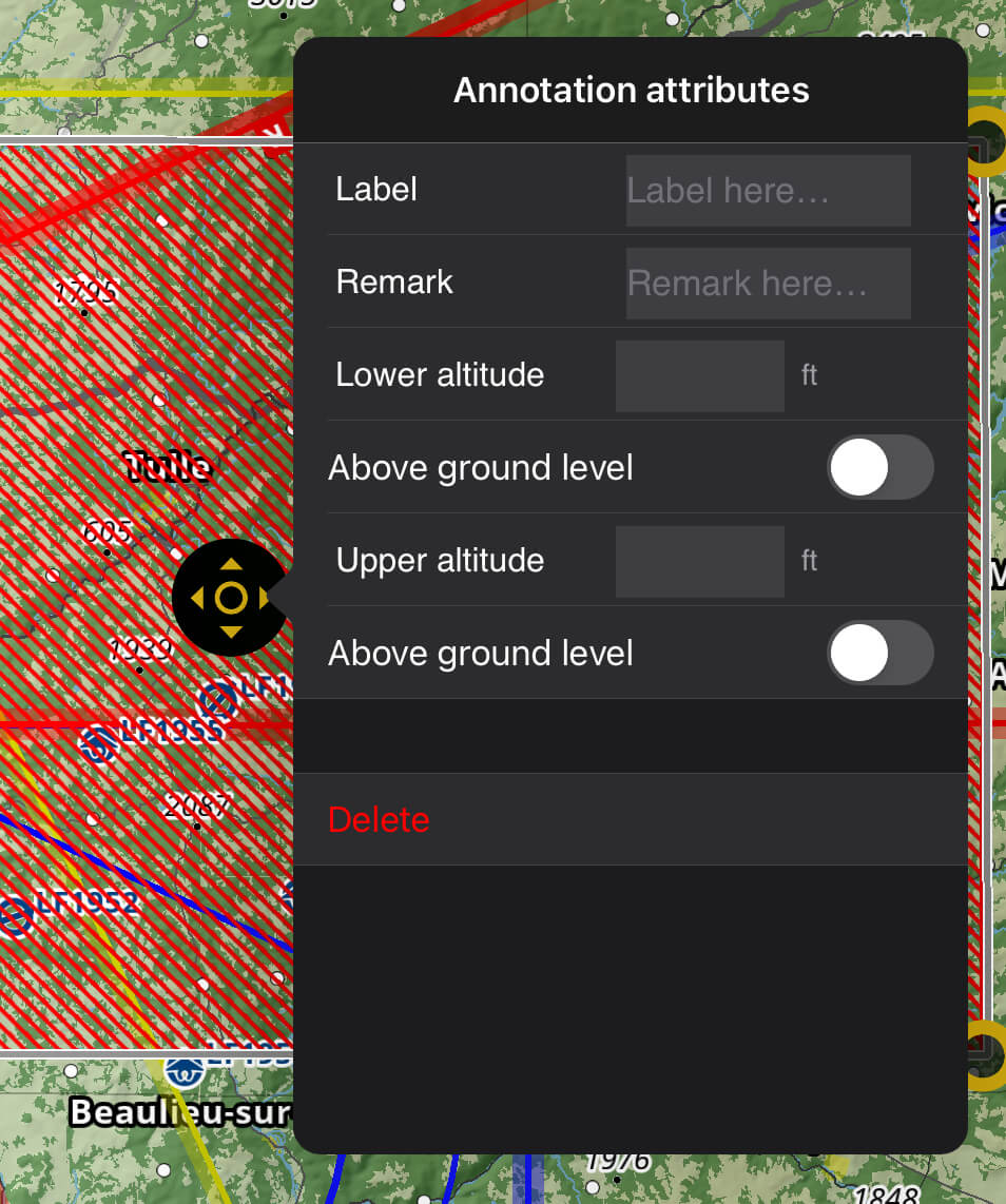
You can add useful information to the Moving Map using map annotations. With this feature, you can highlight, draw geometrical shapes and write with a marker, customizing the color, line thickness and fill pattern. You can also assign attributes to annotations such as labels and remarks and define lower and upper altitudes, allowing you to create your own aeronautical data.
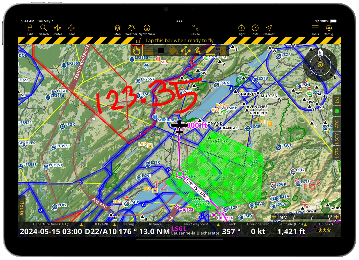
Activate map annotations by toggling ON the related option in Map Options > Guides. An additional toolbar will appear on the Moving Map below the yellow and black striped under-construction bar of the Edit Mode.
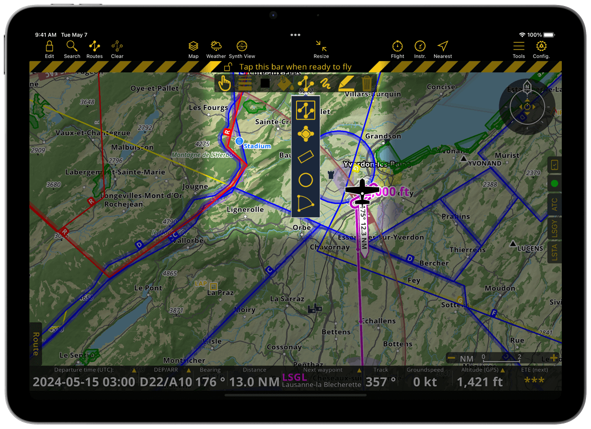
Annotation Toolbar#
The action buttons arranged from left to right are:
Select: Allows you to select, move, resize, change color and line thickness of existing annotations
Line: Allows you to choose the line/outline thickness for annotations supporting it
Color: Allows you to choose the outline and fill color for geometrical annotations
Note
Solid color fills will have some transparency to ensure you can still see the map below the annotation
Fill: Allows you to give geometric shapes a fill option: solid color, no fill or two pattern types
Shape: Allows you to create lines or geometric shapes by selecting an options: polyline, polygon, rectangle, circle and sector. Once the shape is selected, tap on the map to start creating it.
Free draw: Allows you to draw and write on the map with your finger
Highlighter: Allows you to highlight a map area with a bright color
Delete: Allows you to delete a selected annotation
After creating an annotation, select it and tap on the black center icon to open the attributes window.
Annotations will remain displayed on the Moving Map until you delete them or disable the feature on Map Options > Guides. You can find the list of all your annotations on Tools > KML files & Map annotations. Tap on any annotation of the list to see it centered on the map. You can delete individual annotations by sliding it to the left or delete them all together using the ![]() icon in the top right corner.
icon in the top right corner.
You can also display map annotations on the Profile View.
Map Interactions#
You can interact with the moving map by using familiar touch gestures:
Tap a waypoint, airspace, weather station or NOTAM to reveal detailed information about it
Touch and drag to pan the map
Pinch with two fingers to zoom in/out
Touch with two fingers and rotate to rotate the map
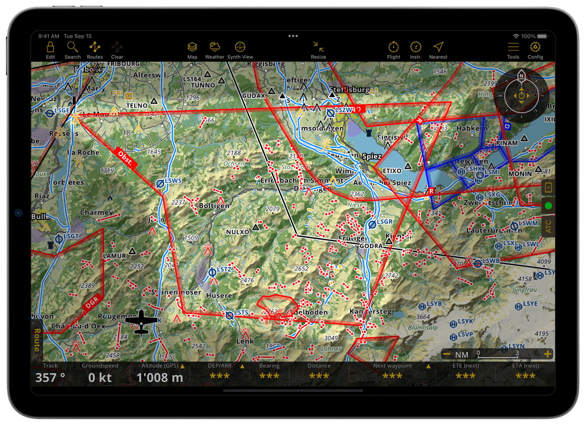
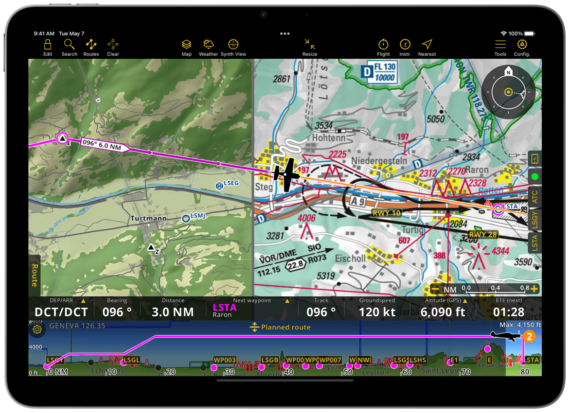
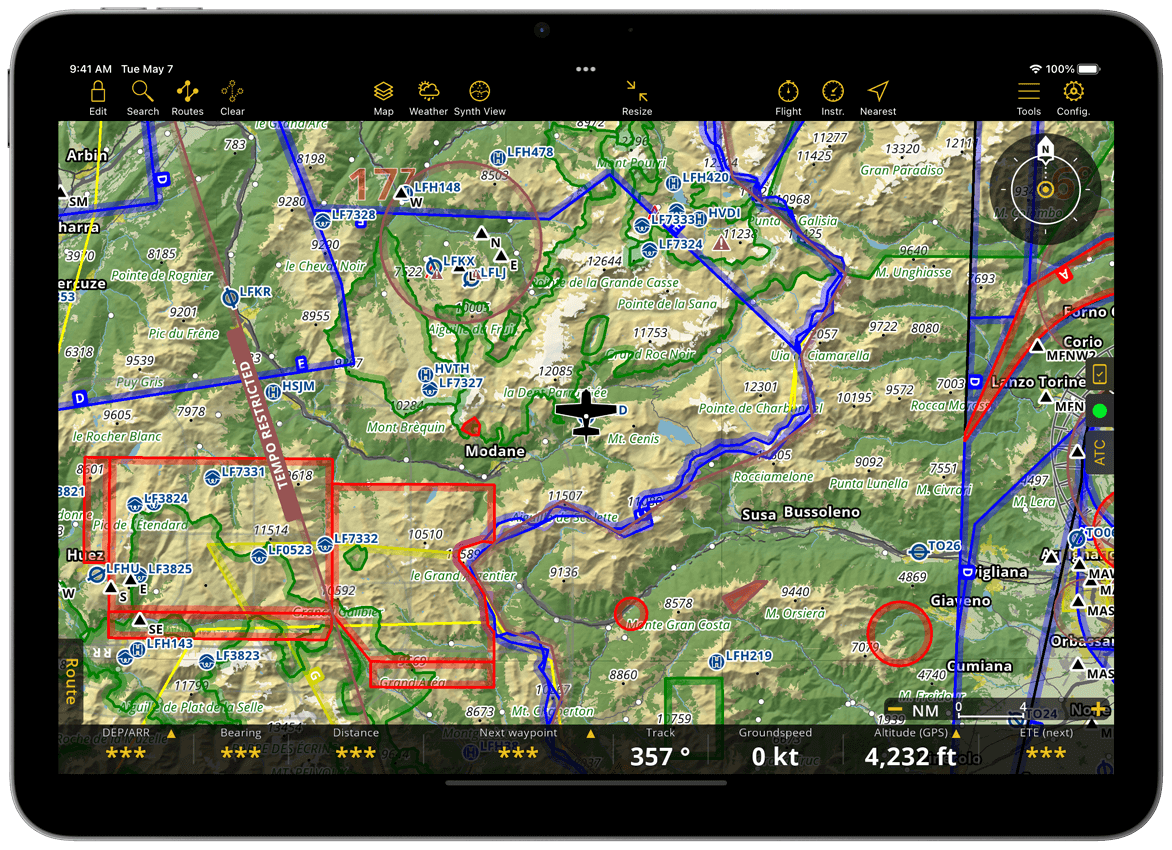
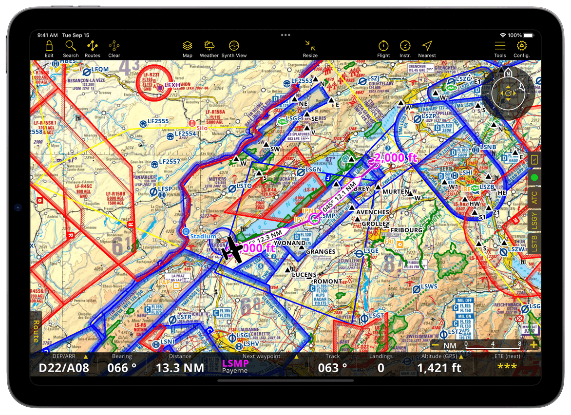
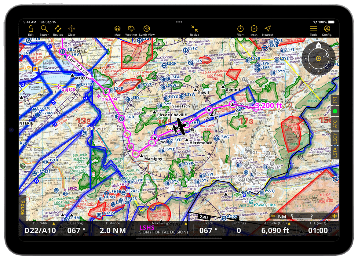
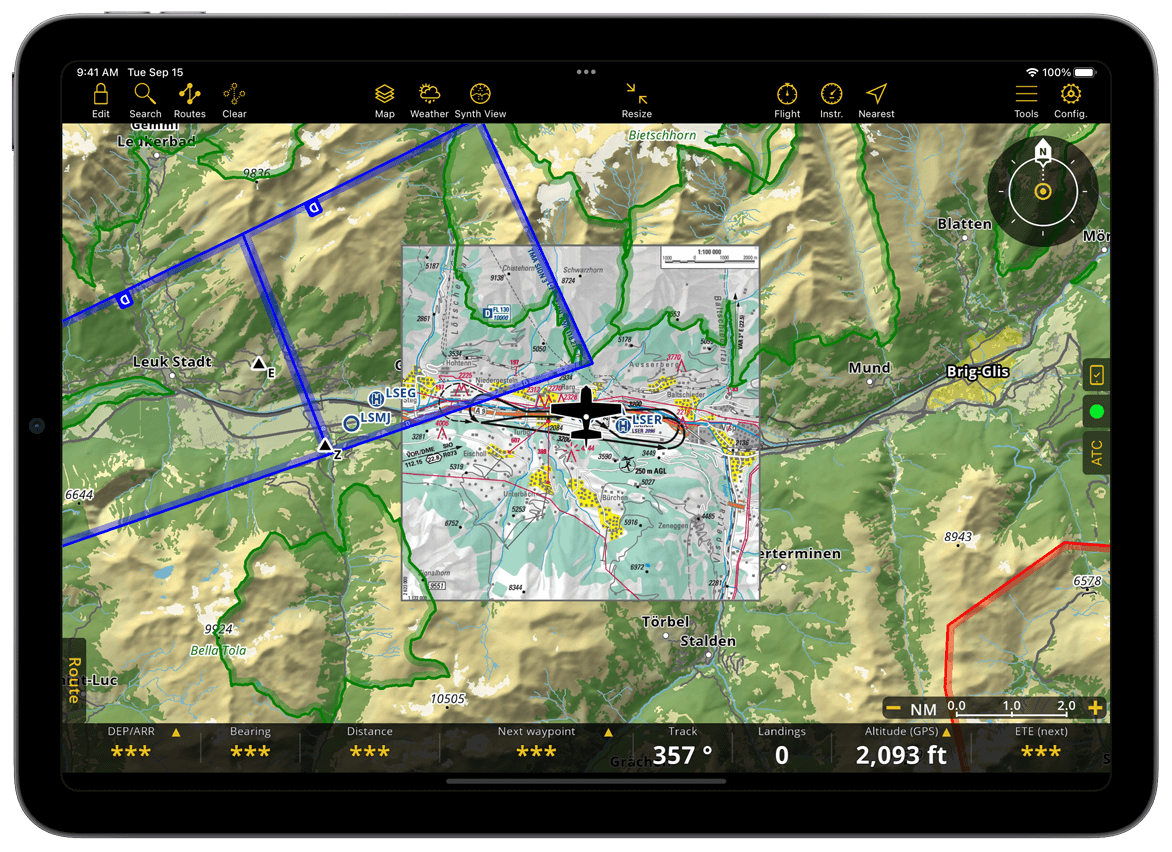
Here is how the moving map with SmartChart looks with an Approach Chart on overlay, a planned route, airspaces and some NOTAMs
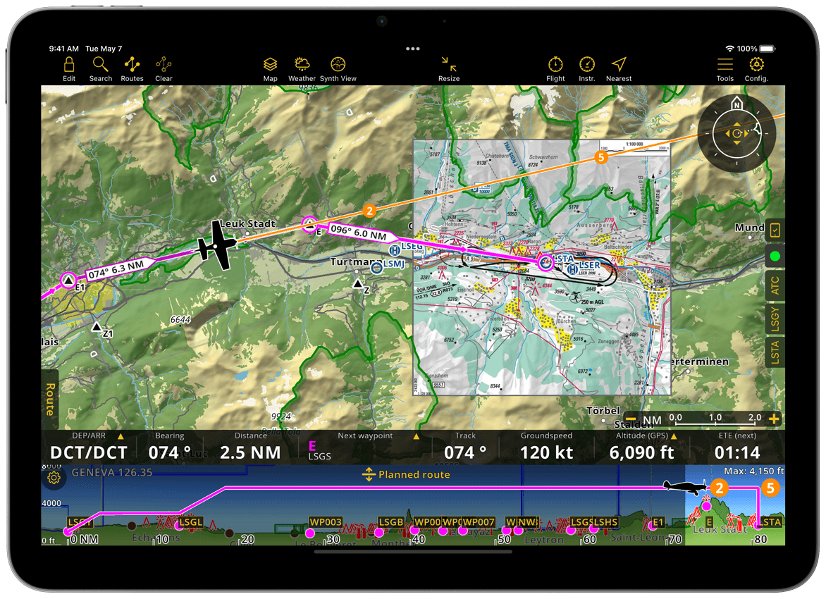
Scaled at 1.5 NM, here is how the moving map with SmartChart looks with an Approach Chart on overlay, a planned route, airspaces and some NOTAMs.
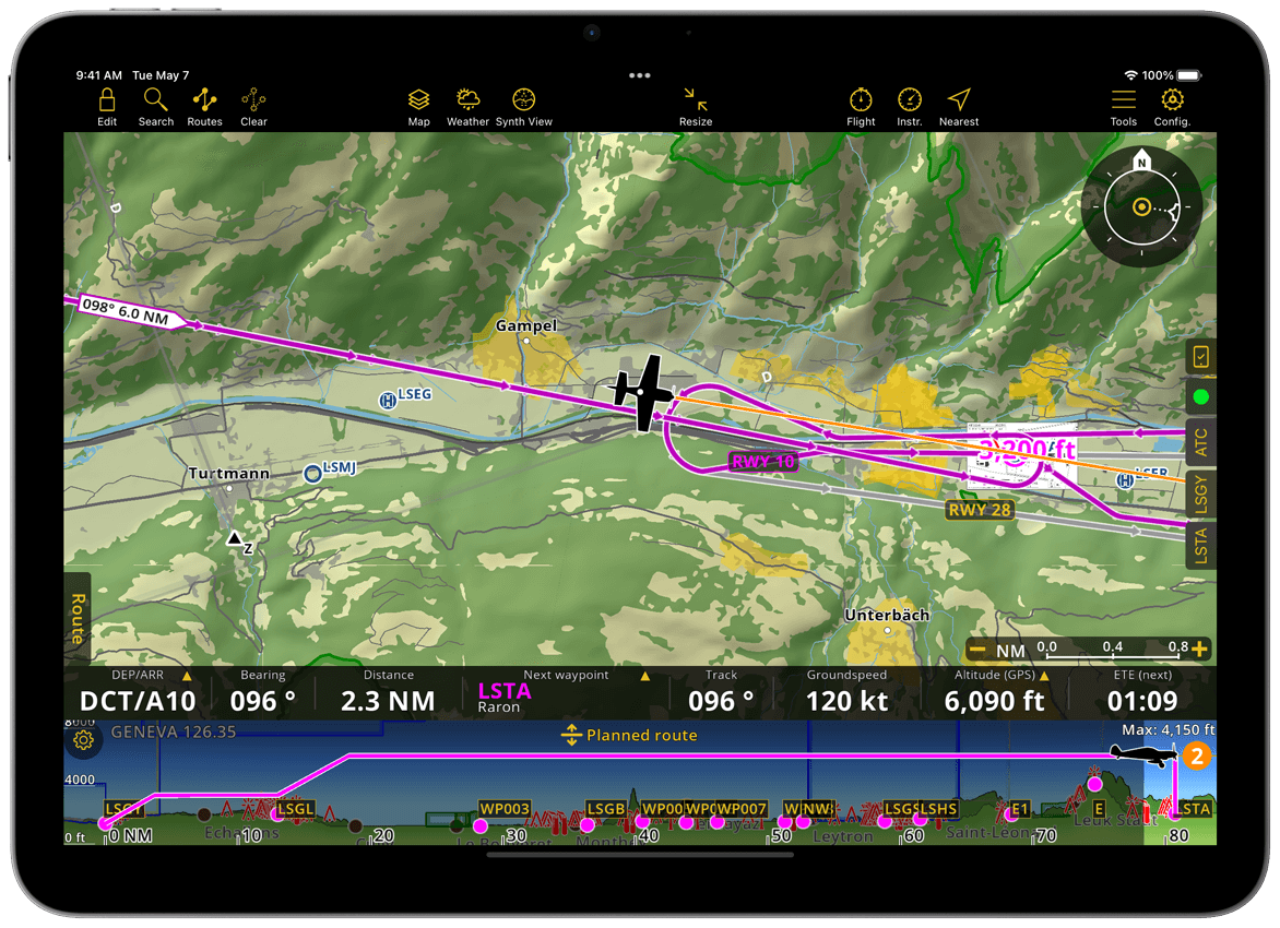
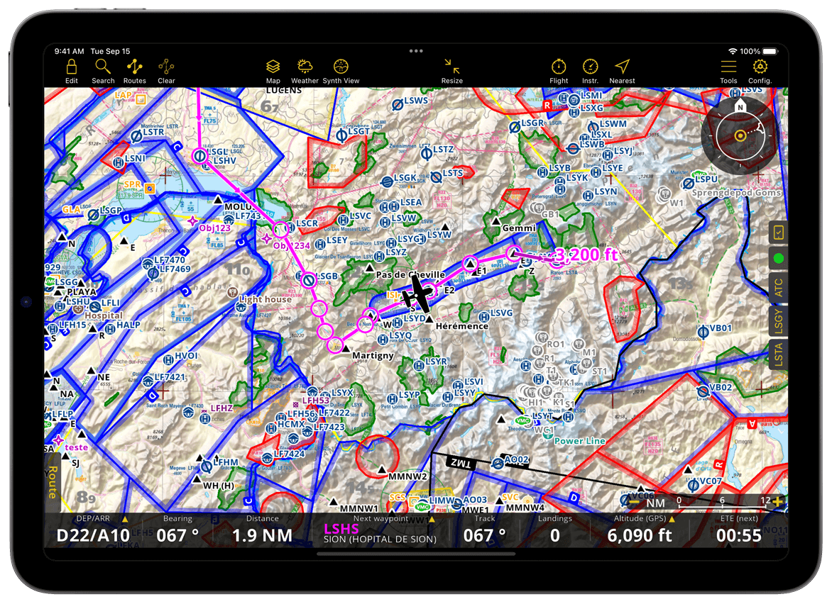
The same moving map with the Approach Chart overlay disabled.
Map Widget#
Position indicator#
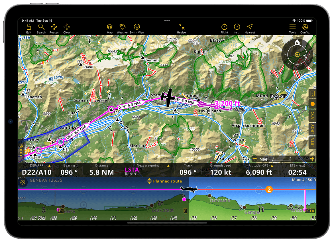
Your current position is shown using an aircraft icon representing your aircraft.
If GPS accuracy becomes insufficient, the aircraft icon is replaced by a circle centered on the last known position. The circle is automatically removed after a few seconds if no valid position update is received.
Interactive aircraft position#
If the aircraft is outside the visible map area, it appears as a bubble showing its distance from the current view center.
Tap the bubble to recenter the map on the aircraft.
For more information about map controls, refer to Map options menu.
Compass Rose#
The Compass Rose Widget controls how the Moving Map is centered and oriented relative to the aircraft. It also reflects real-time changes when the user pans, rotates, or recenters the map.
The widget always shows the current map state.
North mode
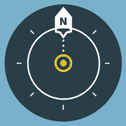
The map is oriented to geographic north.
Track mode

The map is oriented along the aircraft’s ground track.
Note
Track mode is only accurate when the aircraft is moving.
Panned mode

When the user manually moves the map, it switches to panned mode. The map remains fixed to the selected area while preserving the current orientation mode.
If the aircraft is outside the visible screen area, tap the compass once to recenter the map on the aircraft.
Long-press the compass rose to lock or unlock map movement.
Eye altitude#
The zoom controls (+ / -) are displayed at the bottom right of the map. When zooming in or out, the map scale appears next to them, indicating the current map range.
Eye altitude represents the approximate visible map radius. By default, it is shown in nautical miles (NM). You can change the unit in Configuration > Settings > Units.
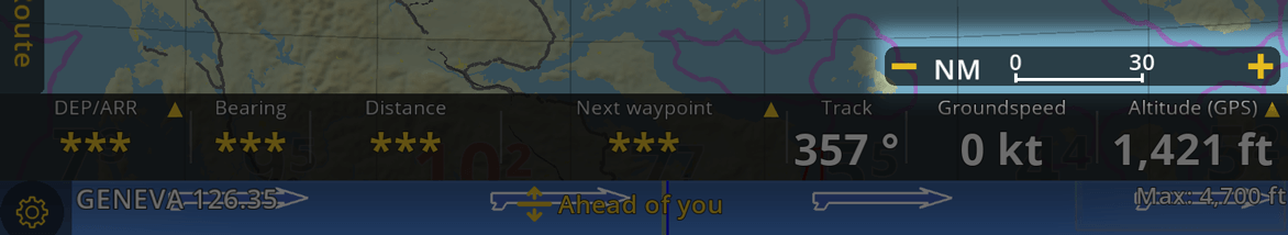
Depending on the current map context, additional shortcut buttons may appear above the scale bar:
Zoom Route: Available when a route is active. Centers and zooms the map to the full route.
Zoom Approach Chart: Available when an approach chart is displayed. Centers and zooms the map on the selected chart.
Note
The scale bar and shortcut buttons are visible for approximately 5 seconds after interaction and reappear when zooming or panning.
Tip
You can pinch with two fingers to zoom in or out. The scale bar updates dynamically based on zoom level.
Map Background#
SmartChart#
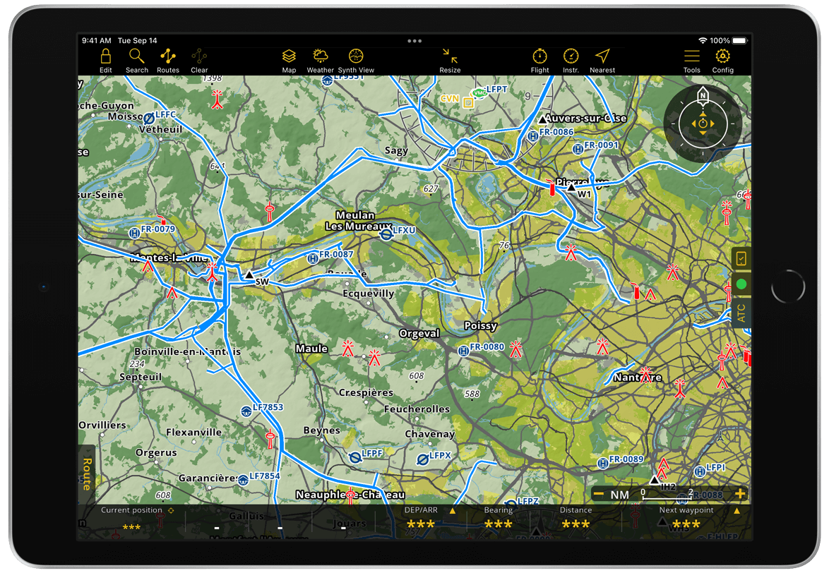
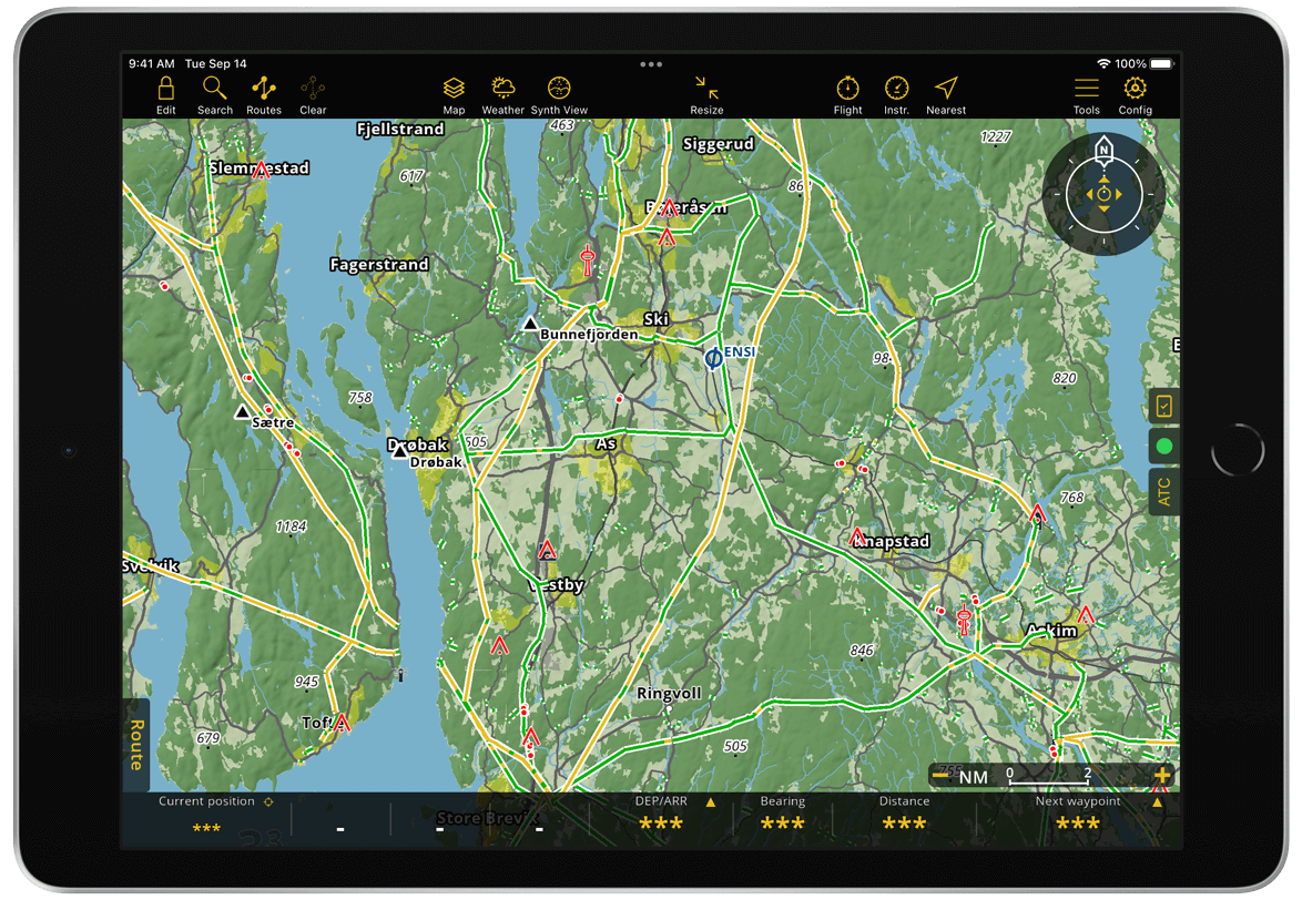
SmartChart is a worldwide vector map included in all subscription plans. The app generates the map in real time using topographic and aeronautical data.
Because the amount of data required to represent the Earth is very large, it cannot be fully stored on your device. SmartChart automatically selects and downloads the most relevant data for offline use.
For safety reasons, the following data is always available on your device:
Aeronautical database of airspaces and waypoints (worldwide)
Country borders (worldwide)
MORA Grid (worldwide)
Any third-party chart, approach chart, and map installed by the user
SmartChart also automatically downloads and updates additional data such as terrain, satellite images, and landmarks:
Around your current position
Around your active route
All downloaded data is stored within a defined storage limit.
Key benefits of SmartChart:
Clear and relevant information at every zoom level
Additional data layered over raster charts
Rotating shadows for better terrain visualization
Labels remain readable regardless of chart orientation
Supports dark mode
Consistent design across all countries
Fine-tuned display for optimal readability
Fully functional at extreme latitudes
Satellite view available
You can also download a specific area around a waypoint or route for offline use. See Data downloads.
Easy to fly thanks to SmartChart#
Because data is downloaded dynamically, you can instantly view your surroundings and start preparing your flight.
You can zoom out to view the entire globe, making it easy to navigate to another region.
MORA Grid#
Displays the minimum safe altitude for each area to help avoid terrain and obstacle collisions.
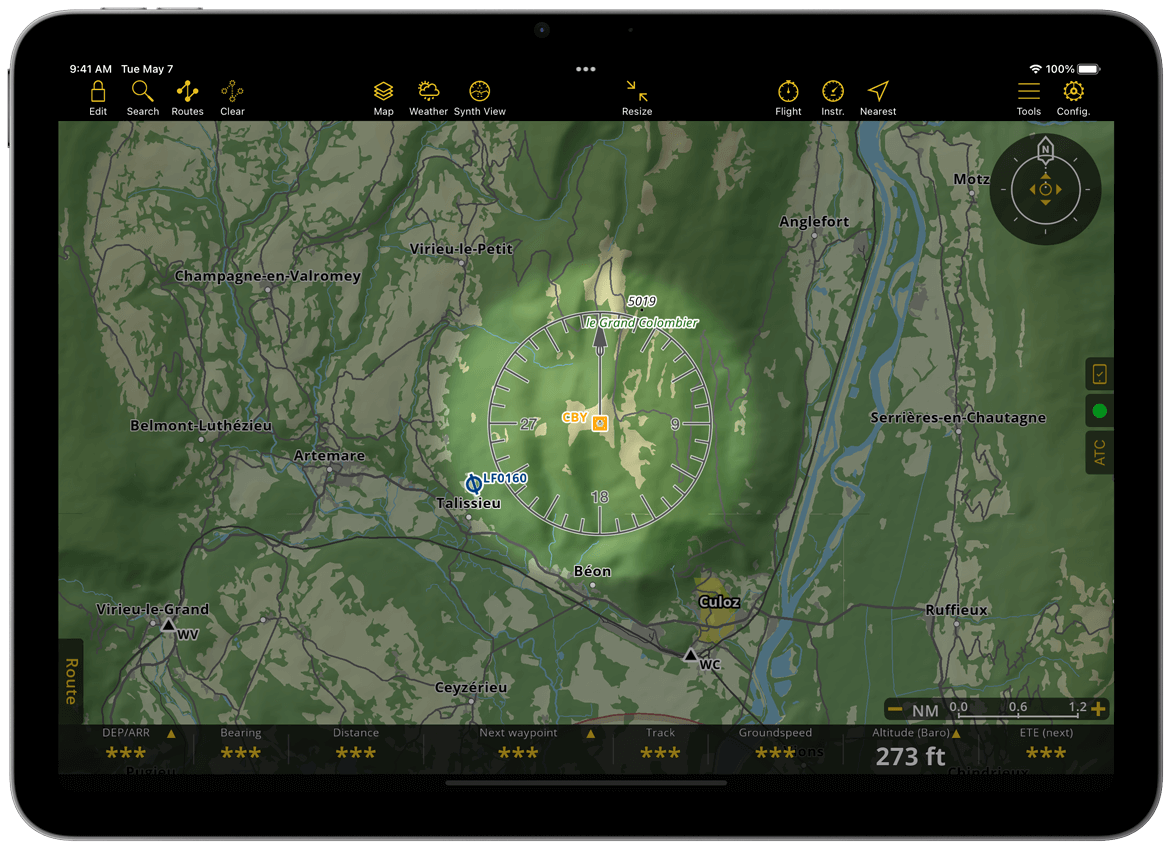
VOR Rosas#
VOR rosas are centered on waypoints and oriented to the north of the chart.
Toponyms#
Natural features (mountains, rivers, lakes) and populated areas (cities) are displayed on the map to improve situational awareness and navigation.
Land covers#
The base terrain is color-coded according to land type, such as forests, urban areas, and wetlands.
Third party charts#
Air Navigation Pro supports a wide range of third-party charts that can be displayed on the Moving Map. This is useful if you prefer navigating with familiar conventional charts.
Charts are provided by trusted partners and can be purchased through the in-app Store or via our website. Visit this page to see available providers.
Note
You can install multiple maps and display them simultaneously. When maps overlap, priority is determined by the order set in Map Options > Maps. You can also import your own maps. See User Maps.
ICAO Chart#
VFR Chart#
Alps VFR Chart#
Topographic Chart#
Glider Chart#
Helicopter Topographic Chart#
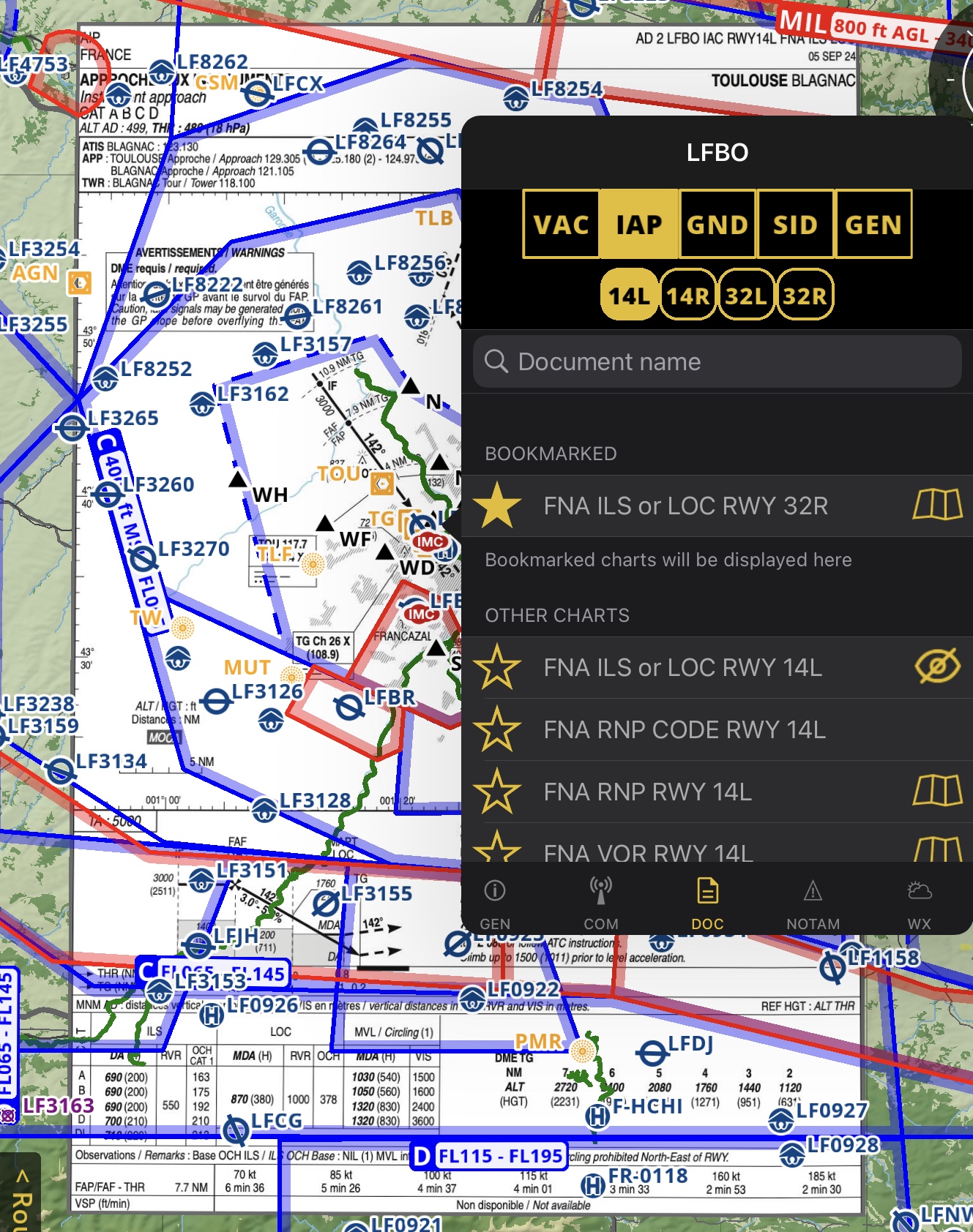
Approach charts#
Air Navigation Pro supports both Visual Approach Charts and Instrument Approach Charts.
Countries that have approach charts#
Approach charts are displayed directly on the map for supported countries.
Below is the list of available countries:
Argentina |
Austria |
Baltic (EST,LVA,LTU) |
Benelux |
Brazil |
Chile |
Colombia |
Czech + Slovakia |
Denmark |
Finland |
France |
Germany |
Greece |
Israel |
Italy |
Norway |
New Zealand |
Russia |
Slovenia |
Spain |
Switzerland |
Uruguay |
USA |
South Africa |
You can purchase them here, by selecting one of the countries above.
You can install all charts for a country or select specific charts per waypoint. These are available as individual products or within subscription packages.
Install approach chart#
Tap Config > Store
Tap Restore and wait until all products are loaded
Select the desired georeferenced approach chart package
Choose specific charts or tap Install all
Display them on the moving map#
Tap an aerodrome with available approach charts
Open the DOC tab
Select a chart and tap

Example: LFBO approach chart
Hide approach charts#
You can hide approach charts in two ways:
From the waypoint popover: tap
 next to the chart name
From the menu bar: tap the Clear icon, then select Hide approach chart